


The Sagala Trek
Bhutan's ideal 'starter' trek
Of the countless Bhutan treks I’ve hiked myself and organised for others, the Sagala Trek stands out as the country’s ideal “starter pack” hike. It takes just three days, and is one of the less physically demanding routes.
At the same time, the Sagala trek is far less marketed than the more famous ‘easy’ Bhutan treks, such as the Bumdra and Druk Path hikes, giving it the rare combination of accessibility and near-total absence of other tourists. On Sagala I’ve had campsites entirely to myself, and the trail is quiet enough that entire days can pass without seeing another trekker.
The hike, sometimes marketed as the “Haa Planter’s Trail,” follows an old trade route that once linked the Haa Valley with Paro. Farmers used to carry rice, chillies and butter over the pass, bringing back salt and textiles. These days, you’re unlikely to meet more than the odd villager using the trail, but you are quite literally walking Bhutan’s old trade path.
Good to know
- Difficulty: Mild/Moderate
- Duration: Three days
- Distance: Approx. 30 km
- Accommodation: Camping
Key information
| Destinations | Bhutan |
|---|---|
| Activity | Adventure, Backpacking, Trekking, Active, Walking, Camping, Nature & Wildlife, Culture, Responsible Travel, Slow Travel |
| Physical Level | Moderate |
| March - November |
Featured tours

Featured tours


The Sagala Trek itinerary

Talung to Sagala
Day 1 in Talung
Approx. 9 km / 4–5 hours / +480m ascent
The journey begins with a drive from Haa to the settlement of Talung, where the trek starts. The route climbs gradually at first, passing through blue pine forest and cultivated farmland. As the trail ascends, it becomes steeper and winds along small streams lined with rhododendron, juniper, spruce and birch.
After skirting the right side of a small village, the path leads past a seasonal yak herders’ camp before the final steady ascent to the campsite at Sagala, situated in open highland terrain.

Sagala to Nigula
Day 2 in Sagala
Approx. 7 km / 4–5 hours / +950m ascent / –250m descent
Leave Sagala and begin climbing towards the Sagala Pass (3,550m). On clear days, there are wide views of the snow-covered peaks of Jomolhari (7,314m) and Jitchu Drake (6,989m).
From the pass, the trail continues along the right-hand ridge, with a series of ascents and descents through high meadows and rhododendron forest. The route eventually climbs to a ridge-top at around 4,100m, offering extensive views across the Haa Valley below.
The path then dips and rises through more forest, mainly hemlock and juniper, before reaching the campsite at Nigula, a high pasture at around 3,800m.

Nigula to Chele La Pass
Day 3 in Chele La
Approx. 10 km / 6–7 hours / +500m ascent / –360m descent
Begin the day with a short descent, then follow a ridge trail through open meadows and past another yak herder’s camp. The climb continues through tall rhododendron forest to the Kung Karpo sky burial site at around 4,350m. From here, there are expansive views of the Haa Valley and, further along the ridge, of the Paro Valley to the east.
The trail follows the ridgeline, rising and falling across open ground marked by stone cairns. On the descent, you'll pass above Kila Goenpa, a cliffside nunnery tucked into the mountainside, before reaching the Chele La Pass (3,756m), one of the highest road-accessible passes in Bhutan. From here, road transport can be arranged to continue onward.
Sagala Trek need to know
The trail winds out of Haa through forest and meadows, climbing to ridges with views across to the higher Himalaya when the weather cooperates. It’s a varied walk, enough to feel like a real trek, but nowhere near as gruelling as the Jomolhari or Bhutan’s other big beasts.
Birdlife is a highlight: I’ve seen blood pheasants and great parrotbills here, along with coal tits and yuhinas. Musk deer are far harder to glimpse; in all my hikes in the Bhutan mountains, I’ve only heard of one or two sightings.
Difficulty
It’s billed as an easy trek, but there are a couple of catches. Nights under canvas can be very cold, even in spring I’ve woken to frost on the tent. And at Ningula campsite, the water supply sometimes dries up. When that happens, groups push on to Kalela, about four kilometres further and up a stiff climb. If you camp at Ningula, the walking feels easy to moderate; if you’re forced to Kalela, it’s a much tougher day.
Otherwise, the daily stages are manageable for anyone of average fitness. It isn’t designed to test your limits, but to give you a taste of Bhutan’s landscapes without committing to a long expedition.
Trek logistics
Like every trek in Bhutan, Sagala must be booked through a licensed operator. You camp throughout, with tents and food provided by the trekking crew. Meals are straightforward: rice, vegetables, sometimes meat – hearty enough but not elaborate. Drinking water is boiled at camp, though I still carry purification tablets as a backup.
The trek usually starts near Haa and ends close to Paro, with vehicle transfers arranged either side. Most tours structure the hike with cultural sightseeing before and after the trek.
When to go
Spring (March–May) brings rhododendrons and other blooms to the forests, though nights can still be cold under canvas. Autumn (September–November) usually offers clearer skies and mountain views, with cooler, drier days. The trek is too short to be dramatically affected by weather, but be prepared for frosty mornings in either season. As with all Bhutan treks, avoid the monsoon season of July and August.
Other itineraries you might like

Classic Everest Base Camp route
16 day Everest Base Camp trek itinerary
Approx. 16 days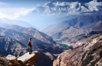
Upper Mustang trek to the Walled City
A trek through Nepal’s restricted Tibetan side
Approx. 14 days
Helambu & Langtang Trek
Crowd-free trekking on Kathmandu’s doorstep
Approx. 16 days

