


Jomolhari trek
Bhutan's classic all-rounder
-
Shana
... -

Jangothang (Jomolhari base camp)
... -
Lingshi
... -
Shodu
... -
Barshong
... -
Dolam Kencho
... -
Dodena
...
I often find myself recommending the Jomolhari trek to visitors as of all the major Bhutan treks, this is probably the best all-rounder. It’s quieter than some of the more accessible routes such as the Druk Path, yet is far more manageable than the big beasts like the Snowman of the Trans Bhutan Trail. But for me, its biggest selling point is a heady blend of incredible scenery with close contact cultural interactions along the way.
Oh – and the scenery of course. As with all of Bhutan’s great hikes, the high-altitude, rugged landscapes are simply mesmerising. You start in pine forests, move into wide, open yak pastures, skirt glacial rivers, and then – boom – you’re at Jangothang Base Camp, staring up at the mighty Jomolhari itself. Seeing Jomolhari for the first time is something you cannot forget.
If you’re looking for a good moderate challenge, I’d say Jomolhari is the one for you. You’ll be hiking at high altitudes and covering long distances, but as long as you’re fit and used to hiking, you’ll be fine.
Key information
| Destinations | Bhutan |
|---|---|
| Activity | Adventure, Trekking, Active, Walking, Camping, Nature & Wildlife, Culture, Responsible Travel, Slow Travel |
| March - October |
Featured tours

Featured tours


Jomolhari trek itinerary
Paro to Thangthangka
Day 1 in Shana
The journey begins with an early drive from Paro to the trailhead at Shana. The trail follows the Paro Chhu river through dense rhododendron and pine forests, with occasional glimpses of traditional farmhouses scattered along the valley. As the route ascends, the valley narrows, becoming wilder and more secluded. A junction along the trail marks the remains of an ancient trading route that once connected Bhutan and Tibet. Several traditional wooden bridges lead to Thangthangka, where the first campsite is set up. If the skies are clear, the snow-capped summit of Jomolhari may be visible in the distance.
Distance: 22 km / 13.6 miles
Duration: 6–8 hours

Thangthangka to Jangothang (4,040m)
Day 2 in Jangothang (Jomolhari base camp)
The trail continues along the river, gradually ascending beyond the treeline. The landscape opens up, revealing sweeping alpine meadows and rugged mountain ridges. Along the way, yak herders’ camps offer a glimpse into the nomadic lifestyle of Bhutan’s highland communities. The day’s trek ends at Jangothang, a spectacular campsite beneath the imposing peaks of Jomolhari and Jichu Drake.
Distance: 17 km / 10.5 miles
Duration: 4–6 hours
Jangothang to Lingshi (4,000m) via Nyele-La Pass (4,700m)
Day 3 in Lingshi
The day begins with a gradual ascent along a glacial river before the trail climbs towards a high-altitude ridge. The effort is rewarded with panoramic views of Jomolhari, Jichu Drake, and Tserimgang. The landscape transitions into a vast, open valley before the final push to Nyele-La Pass (4,700m), the highest point of the day. A steady descent leads to the campsite at Lingshi, with glimpses of the Lingshi Dzong perched on a hilltop in the distance.
Lingshi to Shodu via Yale-La Pass (4,950m)
Day 4 in Shodu
The route continues through an expansive valley before beginning the ascent to Yale-La Pass (4,950m), one of the highest trekking passes in Bhutan. If the weather is clear, there are striking views of Jomolhari, Tsherimgang, and Masagang. From the pass, the trail descends past a chorten (stupa) before following the river down to Shodu, the next campsite.
Shodu to Barshong
Day 5 in Barshong
The trail follows the Thimphu Chhu river, winding through a limestone valley marked by dramatic rock formations and waterfalls. The route passes ancient meditation caves once used by monks, including those associated with the 17th-century spiritual leader Shabdrung Ngawang Namgyal. The day’s trek ends with a gentle climb to Barshong, where the remains of Barshong Dzong stand as a reminder of Bhutan’s historical past.
Distance: 14 km / 8.7 miles
Duration: 4–5 hours
Barshong to Dolam Kencho
Day 6 in Dolam Kencho
The penultimate day of trekking is a mix of gentle ascents and descents, with several river crossings along the way. The landscape transitions between alpine meadows and forests, offering a final opportunity to experience the untouched beauty of Bhutan’s wilderness. The trek concludes at the final campsite in a peaceful clearing.
Final descent to Dodina – return to Thimphu
Day 7 in Dodena
The last stretch of the trek winds through bamboo forests, following an ancient mule track that runs high above the river. A steady descent leads to Dodina, where the trail ends. From here, it’s a short drive to Thimphu.
Distance: 7 km / 4.3 miles
Duration: 3 hours
Need to know
When to go
I’d say the best time to embark on the Jomolhari trek is during the spring (March to May) and autumn (late September to end October). These seasons offer ideal weather conditions and comfortable trekking temperatures. Choose spring if you want lush landscapes and vibrant wildflowers. Opt for autumn for crisp mountain air and the clearest panoramic views of the Himalayas.
Pack smart
The temperature swings are no joke. I was warm in the valleys and absolutely freezing at night. Layering is your best friend!
Prepare well
It’s essential to acclimatise before setting out. Do some warm up hikes if you can, and make sure your endurance is up to scratch.
Other itineraries you might like

Classic Everest Base Camp route
16 day Everest Base Camp trek itinerary
Approx. 16 days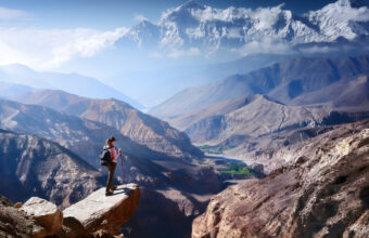
Upper Mustang trek to the Walled City
A trek through Nepal’s restricted Tibetan side
Approx. 14 days
Helambu & Langtang Trek
Crowd-free trekking on Kathmandu’s doorstep
Approx. 16 days

Golden Triangle & Andaman Islands Itinerary
Desert island beaches and Royal Bengal tigers
Approx. 11 days
Find a Bhutan specialist
Tell us about your trip and we'll find your match
We'll connect you directly with the experts.


We'll connect you directly with the experts.
- Hand-picked local specialists
- Honest advice from real experts
- Free to use, no hidden fees