Caucasus trekking & hiking
An expert guide to the best treks and hikes in the Caucasus mountains
With epic mountain landscapes that rival anywhere in Europe, fairytale villages, rolling hills and some truly excellent cuisine, the Caucasus mountains are one of the world's best – and most underrated – trekking and hiking destinations.
The Caucasus' trekking industry revolves mostly around Armenia and Georgia. Both countries are well set up for hiking tourism, have some stunning walking country and are well prepared for visitors. There are a good range of long-distance (inn-to-inn) hikes, as well as numerous places suitable for centre-based walking holidays.
Georgia is perhaps the best-known walking destination in the Caucasus, and has welcomed an influx of tourists in recent years. This is an excellent place to try out some long-distance routes, with high mountain peaks, splendid valleys and isolated stone villages. Look out for the many churches and monasteries that frame Georgia’s mountaintops.
Armenia is less about high peaks and more about day-hikes and easier routes. Dilijan National Park has several trails that can be hiked in a day, while the Tatev Monastery hike is almost unbelievably picturesque.
With fewer marked trails than either Georgia or Armenia and a less-developed hiking tourism industry, trekking in Azerbaijan isn't quite so easy. Head to Quba for trails between mountain villages – this is a place to experience the culture as much as the scenery.
Ready to go? Here's our essential guide to trekking in the Caucasus mountains.
The best Caucasus treks
Our expert's top picks
Unless you’re planning on hiking across the entire mountain range, you should expect a hike in the Caucasus to last anywhere from a single day to a couple of weeks. Most travellers opt for guide-led small group tours, with accommodation and essential logistics all pre-organised. Here are a handful of my favourite treks and hikes in the Caucasus Mountains.
-

Gegham Mountain trail
-

Transcaucasian Trail in Armenia
-

Tusheti to Khevsureti trek
Five day, 78km hike
-

Alternative Mestia to Ushguli trek route
-

Mestia to Ushguli trek (standard route)
-

Truso Valley to Kelitsadi Lake trek
-

Parz Lake day hike
-
Mount Aragats from Lake Kari
-

Stepantsminda to Gergeti Glacier day hike
-

Tobavarchkhili lakes
-

Svaneti to Racha trek
-

Imereti to Racha trek
-

Selim to Ughedzor
-

Tatev day hikes
-

Hiking in Borjomi-Kharagauli National Park


Featured Caucasus Treks
Guided Armenia Walking Holiday
10-day itinerary to Armenia's best hiking spots
10 days €1,380 – €1,540 pp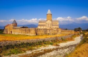
Classic Caucasus
Explore the best of Azerbaijan, Georgia and Armenia
17 days From £2,939 ppWhere to go trekking in the Caucasus
Our experts' top picks

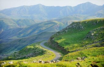
Gegham Mountains
Gegham Mountains
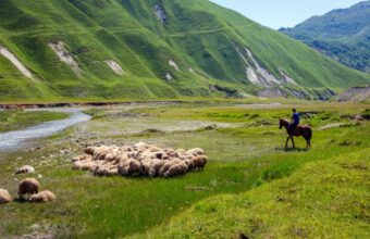
The Gegham Mountains, immediately between Yerevan to the west and Lake Sevan to the east, are a dramatic chain of hills and volcanic peaks that are almost entirely untouched by tourism.
The Geghams are largely impassible over the winter months, but in the summer there's probably nowhere better to go hiking or walking in Armenia. Most hiking trips here focus on Mt Azhdahak, and are run as camping expeditions, possibly with 4WD support. In addition to scaling Azhdahak you'll see some glorious snowmelt lakes (Vishapalich is a gem), some interesting prehistoric petroglyphs, and maybe nomadic herders bringing their cattle to graze.
I have personally developed and pioneered the "Gegham Mountain trail," a 50km hiking route which takes three to four days of remote trekking through the region's glorious alpine meadows, snowmelt lakes, prehistoric petroglyphs and – a highlight for most – scaling Mt Azhdahak.
Read more
Armenia
Dilijan National Park
Known as the ’Switzerland of Armenia,’ Dilijan National Park is a mountainous area covering 240 square kilometres with some of the best and most care-free hiking in the country.
You’ll find beech and oak forests populated with brown bears, wolves, deer and eagles as well as an abundance of fresh fruit including apricots and berries. The town of Dilijan is a wonderful place to recharge in between hikes with plenty of quality accommodation and delicious restaurants.
How to get to Dilijan National Park
You can take a marshrutka (minibus) from the Hyusisayin Avtokayan station in the north of Yerevan between 9am and 6pm. Minibuses leave when full and take about two hours to get to the central roundabout in Dilijan. The cost of the trip is about 1000 Armenian drams.
A taxi from Yerevan to Dilijan could cost up to 14,000 drams for the 100km journey.
When in Dilijan, there are plenty of taxis that can take you to surrounding towns or to your accommodation, though the town is quite small so it’s easy to walk around.
If you’d prefer to drive, there are several rental car agencies at the airport in Yerevan and it’s an easy drive along the M4 highway.

Svaneti
Georgia's hiking hotspot
Svaneti is one of the most popular hiking regions in Georgia, attracting keen walkers as well as casual tourists. Its popularity means Svaneti can feel somewhat overrun during peak season, but it doesn’t negate the region’s unquestionable charm.
My favourite hiking spot in Svaneti is the mediaeval village of Ushguli, whose ancient defensive towers are hemmed by the majestic Mount Shkhara. Walking here feels like stepping back in time, especially when you first catch sight of Ushguli's stone towers against the snow-capped peaks.
Although Svaneti is a year-round destination, most travellers flock here in summer for hiking and in winter for skiing. Summer, particularly August, is peak season, and the famous Mestia-Ushguli trek can get crowded. I prefer this alternative route instead.

Armenia
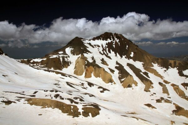
Mount Aragats
Armenia’s borders might no longer contain Mount Ararat, the country’s national monument said to be where Noah’s ark first landed, but it does have Mount Aragats, a beautiful mountain in its own right and modern Armenia’s tallest peak. On Mount Aragats you’ll find waterfalls, sheep-covered valleys and pristine snow-capped mountains. To avoid the coldest temperatures, climbing is best between July and September, but don’t be surprised if there’s snow well into August.
How to get to Mount Aragats
There’s no public transport to Mount Aragats, so you’ll have to get to Kari Lake via taxi from Yerevan (about 10,000 drams) or by renting a car. The drive is 84km and takes about an hour and a half.
Many choose to get to Mount Aragats by hitchhiking, especially on weekends in the summer, but while hitchhiking is a popular way to get around in Armenia it's not recommended as it involves inherent dangers.

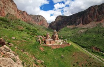
Armenia
Tatev Monastery
Since as far back as the 9th century, Tatev Monastery in the south of Armenia has commanded a bold place overlooking one of Armenia's most epic sights, the Vorotan Gorge, which dips 800m beneath stark cliffs. The gorge is a sublime destination for day hikes with trails leading to tiny villages and important cultural sights.
How to get to Tatev
There are no marshrutky (minibuses) to Tatev or Halidzor from Yerevan, but you can take one to nearby Goris and then onto Tatev from there. Marshrutky leave Yerevan’s Sasuntsi Davit metro station for Goris at 9am and 4pm and take about six hours (2500 drams). From Goris, minibuses leave for Tatev at 8:30am and 3:30pm from the bus stop on Komitas St and take an hour.
There are shared taxis from Yerevan to Halidzor, but not to Tatev. Ask at your accommodation in Yerevan to have one pick you up. A private taxi from Goris should cost 8000 drams.
The drive from Yerevan is 250km and takes about five hours.

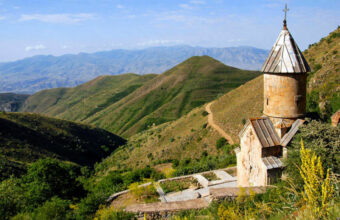
Armenia
Yeghegis Valley
Surrounded by huge peaks, charming villages, medieval churches and roaming animals, the Yeghegis Valley in Armenia’s Vayots Dzor province is excellent hiking territory. Don’t believe me? Take it from the Silk Road merchants who passed through here on their way to and from Western Europe and Asia. You can still find evidence of their journeys with a well-kept 14th-century caravanserai (shelter for weary travellers) in the Selim Pass. Summers in this region can get very hot at midday, so hiking between May and June or October and November is ideal.
How to get to the Yeghegis Valley
Buses leave Yerevan from the Sasuntsi Davit train station in the morning for Yeghegnadzor, the area’s main hub, and take about two hours (AMD1200). From there, you’ll need to take a taxi up to Artabuynk or the Selim caravanserai, which costs the standard AMD100 per kilometre rate.
A taxi from Yerevan to Yeghegnadzor costs about 15,000 drams and takes two and a half hours.
Driving is a good idea as there’s plenty to explore in the region but few buses to take you there. However, keep in mind that if you’re planning to do the Artabuynk to Yeghegis or Selim to Ughedzor hikes they aren’t loops, so you’ll have to find your way back to where your car is parked.

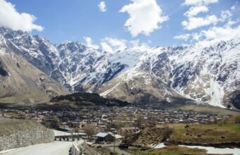
Kazbegi
Georgia's most famous landmark
Located close to Tbilisi, Kazbegi is another of Georgia’s most popular hiking regions – often visited as a day trip from the capital.
Stepantsminda village, in the centre of the Kazbegi region, is famous for its scenic landscapes, especially the Gergeti Trinity Church, topped on a hill with Mt. Kazbegi in the background.
This is probably the most recognisable location in Georgia, but don’t be fooled by the misleading marketing photos – this is no quiet mountain getaway. The church gets busy with day trippers and the highway, linking Georgia with Russia, occasionally sees heavy traffic and long lines of trucks.
Despite the crowds, I still enjoy hiking here for the breathtaking views and architectural sights close to Tbilisi.
July and August are ideal, with warm, long days perfect for trekking. Early summer features lush green valleys against snowy peaks, but rain is common.

Kakheti region
Good wine & great walks
Kakheti is associated more with wine than hiking, but it does have two lesser-known national parks, Lagodekhi and Vashlovani, both of which have some good trails.
Lagodekhi, the country's oldest national park, is home to stunning Black Rock Lake, a natural border between Georgia and Dagestan in Russia. As you venture through the trail, the landscape shifts dramatically from the thick, leafy beech forests to expansive high-altitude meadows, culminating in a pristine alpine lake.
Vashlovani, on the other hand, offers an entirely different experience. It is located near the Azerbaijan border and boasts surreal landscapes of narrow canyons, savannah with pistachio trees, mud volcanoes, and rugged peaks. The semi-desert terrain of Vashlovani makes hiking impractical. Instead, you’ll need a 4x4 vehicle and permits (obtained at the visitor centre in Dedoplitsikaro; bring a passport and cash), and be prepared for long drives with short hikes. Avoid visiting in high summer due to extreme heat and venomous snakes.

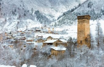
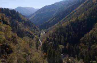
Tusheti
My no.1 Georgia hiking spot
Tusheti is my favourite place to go hiking in Georgia. This is one of the country's most stunning mountain regions, located just behind the main ridge of the Caucasus.
It boasts unspoiled nature and remote trails, but hasn’t suffered the commercialisation of the more popular Svaneti region. The Tush people have a strict rule restricting outsiders, including fellow Georgians, from starting businesses unless they have ties to the area.
Tusheti may not boast soaring peaks and rugged landscapes like Svaneti, but its mediaeval villages, defensive towers, and unusual mix of paganism, Christianity, and Islam make it a fascinating place to visit.
It is only accessible by an unpaved, narrow serpentine road called Abano Pass, dubbed the 'scariest road in Georgia.' Due to snow, the pass closes from late fall to late spring, making summer and early autumn the only feasible seasons.

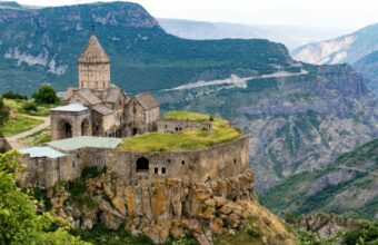
Azerbaijan
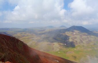
Gobustan National Park
An hour’s drive from Baku near the Caspian coast, Gobustan National Park’s mud volcanoes, mountains and rock art make it the perfect place to try a few day hikes.
Gobustan is probably best known for its mud volcanoes. More than half the world’s mud volcanoes are found in Azerbaijan, and Gobustan has more than its fair share. Mud volcanoes are actually more like mud geysers, with methane and carbon dioxide being released from the holes causing the mud to bubble and boil. The hot climate causes the mud to solidify rapidly, creating cracks and fissures in the floor.

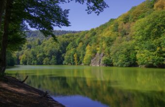
Samegrelo & Tobavarchkhili
Breathtaking views without the crowds
Samegrelo, a western region of Georgia bordering Svaneti, is often ignored by hikers due to its flat terrain. But the ace up its sleeve is the stunning Tobavarchkhili Lakes, situated beneath the dramatic Egrisi mountains. These glacier lakes offer some of the most breathtaking views in Georgia, with uneven peaks and deep gorges surrounding the pristine waters.

Khevsureti
Lesser-known hiking trails
Khevsureti, sandwiched between the more famous Kazbegi and Tusheti regions and bordering Russia's Ingushetia and Chechnya to the north, is a lesser-known but stunning place to go hiking and walking.
Like Tusheti, the religion here is an interesting mix of Christianity and paganism. Locals worship sacred places such as icons, crosses, and sanctuaries. I love the regions imposing mountains, almost deserted fortified mediaeval villages, ancient shrines and burial grounds, and mountain lakes.
International trekking groups have helped develop the hiking infrastructure in Khevsureti, establishing some well-marked trails. With few tourists, Khevsureti offers a rare opportunity to step back in mediaeval Georgia and see the unspoiled side of the country.
Unlike Svaneti or Kazbegi, Khevsureti is only accessible during the summer months when snow starts to melt.

Racha
Georgia's hiking hidden gem
Racha is often overlooked due to its limited tourist services and infrastructure. But I love the region’s snow-topped peaks, dense forests, alpine meadows and lakes, panoramas of the Great Caucasus mountains – and absence of tourists!
Officially called Racha-Lechkhumi and Kvemo Svaneti region, it is positioned between Svaneti and breakaway South Ossetia, but travelling here is safe. Just remember to carry your ID for inspection by police or border guards.
Hiking trails in Racha are limited, and they may not rival Tusheti, Khevsureti, or Svaneti for hiking enthusiasts. However, some good routes exist, such as the challenging trek to Svaneti, hikes between remote villages, paths to the glaciers, or the stunning Udziro Lake.

Borjomi-Kharagauli National Park
Hiking in Georgia's biggest national park
Located in the Samtskhe-Javakheti region, Borjomi-Kharagauli National Park is Georgia's largest park and was the first to comply with international standards – every trail is well marked and there are designated areas for tents, fires and picnic areas.
The park is accessible year-round and has numerous trails of varying lengths and difficulty levels. Some are circular routes, while others are one-way treks. Basic shelters and designated camping areas are available for multi-day hikes.
Most trailheads start within 30 km of Borjomi town, and others near Abastumani and Kharagauli.
Before starting, you must register at the visitor centres, pay for the cabins (bring cash and a passport), and enquire about trail conditions, as closures are common.
The hiking season is from spring to autumn, although it gets very hot in high summer.
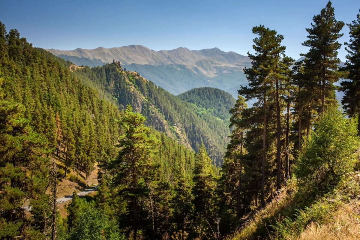
The forests of Tusheti, Georgia
Caucasus trekking: Need to know
Everything you wish you'd known before you booked
When to go trekking in the Caucasus
The weather in the Caucasus is at its most pleasant between June and September when you can expect warm and sunny weather. Temperatures can reach 25°C (77 °F), so make sure you pack appropriate hiking gear. It’s also important to bring mosquito nets and repellant, as the summer heat sees mosquitos descend on the region. The higher you get into the mountains, the less of a problem they will be.
Winter brings heavy snowfall to the Caucasus, making trails difficult to find and impossible to trek. It’s not uncommon for the snow to stay on higher ground until late April or even May, keeping higher routes closed off, even though the lowland is green and lush.
The best time to hike in the Caucasus region is from mid-June until the end of September. The high season is July and August, when the weather is dry and warm, whereas June and September are quieter but less reliable.
Hiking in the winter snow is not possible, but some tour companies do offer ski-touring, particularly in Georgia, which is also home to several ski resorts.
Independent trekking vs organised tours
Georgia is the Caucasus country most set up for independent hiking, with some well-marked trails, plenty of villages used to visitors and a burgeoning hiking community. The Svaneti region is particularly well-suited for independent visitors, with apartments available to rent in villages, lodges preparing lunches and breakfasts and signposted trails.
Beyond that, most independent treks take place in national parks, such as Armenia’s Dilijan National Park or Georgia’s Borjomi-Kharagauli.
Independent trekking has a lot going for it: It’s cheap(er) and can be a lot of fun. Trekking lodges—though far from luxurious—are often warmer and more comfortable than tents, and an increasing number now boast hot showers, varied menus and even wifi. There’s also the option of staying in local villages, although it is difficult to book ahead, so you’re often relying on the kindness of strangers.
The biggest advantage of independent trekking is the ability to change your itinerary as you see fit. If you stay in a village and like the feel of it, you can stay for a few days. If you hear about a side trek or different route you want to try out, you can. However, this positive can also be a negative. Attempt an unusual or unmarked route, and you can end up in the middle of nowhere without a place to sleep. Trying to book accommodation in advance can be tedious and difficult. Language difficulties mean you might spend most of the trip on your own, unable to interact with the people you meet.
Organised Caucasus treks
An organised trek doesn’t have to mean a package tour-style trip with coaches and loads of people. In fact, an organised trek can involve just yourself and a guide, taking off across the Caucasus mountains.
Mostly, an organised trek will involve several hikers of varying degrees of fitness and expertise alongside a couple of guides and potentially a porter, depending on whether you’re doing a multi-day or single day hike.
A fully organised trek comes with the benefits of having your accommodation booked in advance each night. Your guide will know the best places to stop for the night and where you can eat, as well as introducing you to locals and explaining the history and geography of the places you’ll see.
An organised trek also means security. Your guide will know the route and any problems up ahead that independent trekkers would not. They’ll also be able to act as a cultural and language translator, meaning your interactions with locals will be more authentic. Finally, having someone book your accommodation along the way means that you won’t have to carry extra equipment or camping gear (note that it is possible to mix up homestays/village accommodation with an occasional wild camping experience).
Caucasus hiking FAQs
Your questions, our expert answers
Question
Is hiking between Armenia-Georgia-Azerbaijan currently possible?
Are combined or cross-country walking holidays between these three countries possible at the moment?
Answer
It's technically possible, but due to ongoing diplomatic tensions, it's much harder to organise (and therefore more expensive) to organise a cross-border walking holiday between Armenia and Azerbaijan than normal. You'll probably need two separate tour operators for Armenia/Georgia and Azerbaijan, and travel in the walking border regions and remote villages is under strict control of the security services, making cross-border inn-to-inn walking holidays trickier than normal.