Walking holidays in Georgia
The best hiking & walking holidays in Georgia's Caucasus mountains
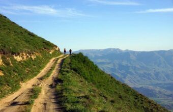
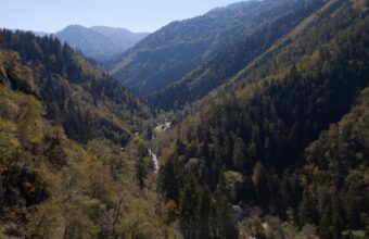
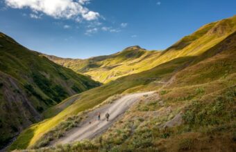
With its picture-book landscapes, rolling hills and fairytale villages, walking in Georgia's Caucasus mountains is a truly sublime experience.
Situated south of the Caucasus mountains, Georgia’s treks and hikes are suitable for most abilities and fitness levels. The country is well geared up for organised walking holidays with plenty of way-marked or guided walking routes, a good range of quality accommodation and, most importantly of all, some truly outstanding food to keep you well fuelled along the way.
For solo trekking, there are few restrictions on setting up camp while exploring the great outdoors, although some restrictions are in place in national parks and state nature reserves with designated camping and fireplace spots. Water is drinkable everywhere and you’re rarely far from a spring to fill up your water bottles.
Ready to go? Here's our essential guide on the best walking and hiking holidays in Georgia.

Information overload?
TL;DR? Get my Georgia hiking highlights straight to your inbox in this free email series.
Georgia walking holidays: At a glance
Overrated: You couldn't really call Georgia a 'mass tourism' destination, but some of our most popular hiking locations can feel busy during peak seasons. The standard Mestia to Ushguli hike gets crowded, as does the Gergeti Trinity Church at Stepantsminda. Fortunately I've got some hacks to avoid the crowds!
Underrated: Probably my favourite places to hike and walk in Georgia are the fascinating and proudly inaccessible Tusheti, and the remote, barely touched Racha region.
When to go: The Georgia hiking season depends on the region and route. In the mountainous regions, the season starts from early summer and continues till early autumn. Winter in Georgia sees heavy snow that blocks roads and trails. Trekking in the winter is only available in national parks, but depends entirely on the weather conditions at the time.
How to do it: Most hiking trips to Georgia are either fully DIY and self-supported or as part of an organised 'multi-centre' walking holiday with road transfers between guided day hikes. Self-guided 'inn-to-inn' walking holidays in Georgia are not common but they are starting to appear with some specialist operators.
The best hikes & walks in Georgia
Popular hikes and hidden gems
-

Tusheti to Khevsureti trek
Five day, 78km hike
-

Alternative Mestia to Ushguli trek route
-

Mestia to Ushguli trek (standard route)
-

Stepantsminda to Gergeti Glacier day hike
-

Truso Valley to Kelitsadi Lake trek
-

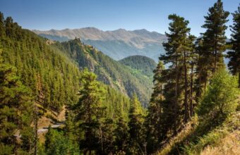
Hiking in Borjomi-Kharagauli National Park
-

Imereti to Racha trek
-

Udziro Lake trek
-

Svaneti to Racha trek
-

Black Rock Lake trek
-

Tobavarchkhili lakes


georgia walking holidays

Armenia & Georgia Walking Holiday
11-day guided hiking tour on picture-perfect mountain trails
11 days From $2,614 pp
 Georgia
Hiking Georgia's Caucasus Mountains
Hike through the spectacular Caucasus Mountains region
10 days From £1,899 ppgeorgia walking holidays
Armenia & Georgia Walking Holiday
11-day guided hiking tour on picture-perfect mountain trails
11 daysFrom $2,614

Hiking Georgia's Caucasus Mountains
Hike through the spectacular Caucasus Mountains region
10 daysFrom £1,899Where to go walking in Georgia
Popular & lesser-known hiking locations

Tusheti
My no.1 Georgia hiking spot
Tusheti is my favourite place to go hiking in Georgia. This is one of the country's most stunning mountain regions, located just behind the main ridge of the Caucasus.
It boasts unspoiled nature and remote trails, but hasn’t suffered the commercialisation of the more popular Svaneti region. The Tush people have a strict rule restricting outsiders, including fellow Georgians, from starting businesses unless they have ties to the area.
Tusheti may not boast soaring peaks and rugged landscapes like Svaneti, but its mediaeval villages, defensive towers, and unusual mix of paganism, Christianity, and Islam make it a fascinating place to visit.
It is only accessible by an unpaved, narrow serpentine road called Abano Pass, dubbed the 'scariest road in Georgia.' Due to snow, the pass closes from late fall to late spring, making summer and early autumn the only feasible seasons.

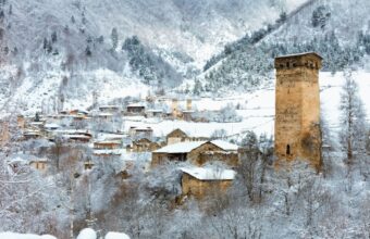
Svaneti
Georgia's hiking hotspot
Svaneti is one of the most popular hiking regions in Georgia, attracting keen walkers as well as casual tourists. Its popularity means Svaneti can feel somewhat overrun during peak season, but it doesn’t negate the region’s unquestionable charm.
My favourite hiking spot in Svaneti is the mediaeval village of Ushguli, whose ancient defensive towers are hemmed by the majestic Mount Shkhara. Walking here feels like stepping back in time, especially when you first catch sight of Ushguli's stone towers against the snow-capped peaks.
Although Svaneti is a year-round destination, most travellers flock here in summer for hiking and in winter for skiing. Summer, particularly August, is peak season, and the famous Mestia-Ushguli trek can get crowded. I prefer this alternative route instead.

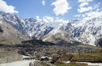
Kazbegi
Georgia's most famous landmark
Located close to Tbilisi, Kazbegi is another of Georgia’s most popular hiking regions – often visited as a day trip from the capital.
Stepantsminda village, in the centre of the Kazbegi region, is famous for its scenic landscapes, especially the Gergeti Trinity Church, topped on a hill with Mt. Kazbegi in the background.
This is probably the most recognisable location in Georgia, but don’t be fooled by the misleading marketing photos – this is no quiet mountain getaway. The church gets busy with day trippers and the highway, linking Georgia with Russia, occasionally sees heavy traffic and long lines of trucks.
Despite the crowds, I still enjoy hiking here for the breathtaking views and architectural sights close to Tbilisi.
July and August are ideal, with warm, long days perfect for trekking. Early summer features lush green valleys against snowy peaks, but rain is common.

Khevsureti
Lesser-known hiking trails
Khevsureti, sandwiched between the more famous Kazbegi and Tusheti regions and bordering Russia's Ingushetia and Chechnya to the north, is a lesser-known but stunning place to go hiking and walking.
Like Tusheti, the religion here is an interesting mix of Christianity and paganism. Locals worship sacred places such as icons, crosses, and sanctuaries. I love the regions imposing mountains, almost deserted fortified mediaeval villages, ancient shrines and burial grounds, and mountain lakes.
International trekking groups have helped develop the hiking infrastructure in Khevsureti, establishing some well-marked trails. With few tourists, Khevsureti offers a rare opportunity to step back in mediaeval Georgia and see the unspoiled side of the country.
Unlike Svaneti or Kazbegi, Khevsureti is only accessible during the summer months when snow starts to melt.

Kakheti region
Good wine & great walks
Kakheti is associated more with wine than hiking, but it does have two lesser-known national parks, Lagodekhi and Vashlovani, both of which have some good trails.
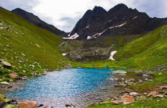
Lagodekhi, the country's oldest national park, is home to stunning Black Rock Lake, a natural border between Georgia and Dagestan in Russia. As you venture through the trail, the landscape shifts dramatically from the thick, leafy beech forests to expansive high-altitude meadows, culminating in a pristine alpine lake.
Vashlovani, on the other hand, offers an entirely different experience. It is located near the Azerbaijan border and boasts surreal landscapes of narrow canyons, savannah with pistachio trees, mud volcanoes, and rugged peaks. The semi-desert terrain of Vashlovani makes hiking impractical. Instead, you’ll need a 4x4 vehicle and permits (obtained at the visitor centre in Dedoplitsikaro; bring a passport and cash), and be prepared for long drives with short hikes. Avoid visiting in high summer due to extreme heat and venomous snakes.

Borjomi-Kharagauli National Park
Hiking in Georgia's biggest national park
Located in the Samtskhe-Javakheti region, Borjomi-Kharagauli National Park is Georgia's largest park and was the first to comply with international standards – every trail is well marked and there are designated areas for tents, fires and picnic areas.
The park is accessible year-round and has numerous trails of varying lengths and difficulty levels. Some are circular routes, while others are one-way treks. Basic shelters and designated camping areas are available for multi-day hikes.
Most trailheads start within 30 km of Borjomi town, and others near Abastumani and Kharagauli.
Before starting, you must register at the visitor centres, pay for the cabins (bring cash and a passport), and enquire about trail conditions, as closures are common.
The hiking season is from spring to autumn, although it gets very hot in high summer.

Racha
Georgia's hiking hidden gem
Racha is often overlooked due to its limited tourist services and infrastructure. But I love the region’s snow-topped peaks, dense forests, alpine meadows and lakes, panoramas of the Great Caucasus mountains – and absence of tourists!
Officially called Racha-Lechkhumi and Kvemo Svaneti region, it is positioned between Svaneti and breakaway South Ossetia, but travelling here is safe. Just remember to carry your ID for inspection by police or border guards.
Hiking trails in Racha are limited, and they may not rival Tusheti, Khevsureti, or Svaneti for hiking enthusiasts. However, some good routes exist, such as the challenging trek to Svaneti, hikes between remote villages, paths to the glaciers, or the stunning Udziro Lake.

Samegrelo & Tobavarchkhili
Breathtaking views without the crowds
Samegrelo, a western region of Georgia bordering Svaneti, is often ignored by hikers due to its flat terrain. But the ace up its sleeve is the stunning Tobavarchkhili Lakes, situated beneath the dramatic Egrisi mountains. These glacier lakes offer some of the most breathtaking views in Georgia, with uneven peaks and deep gorges surrounding the pristine waters.
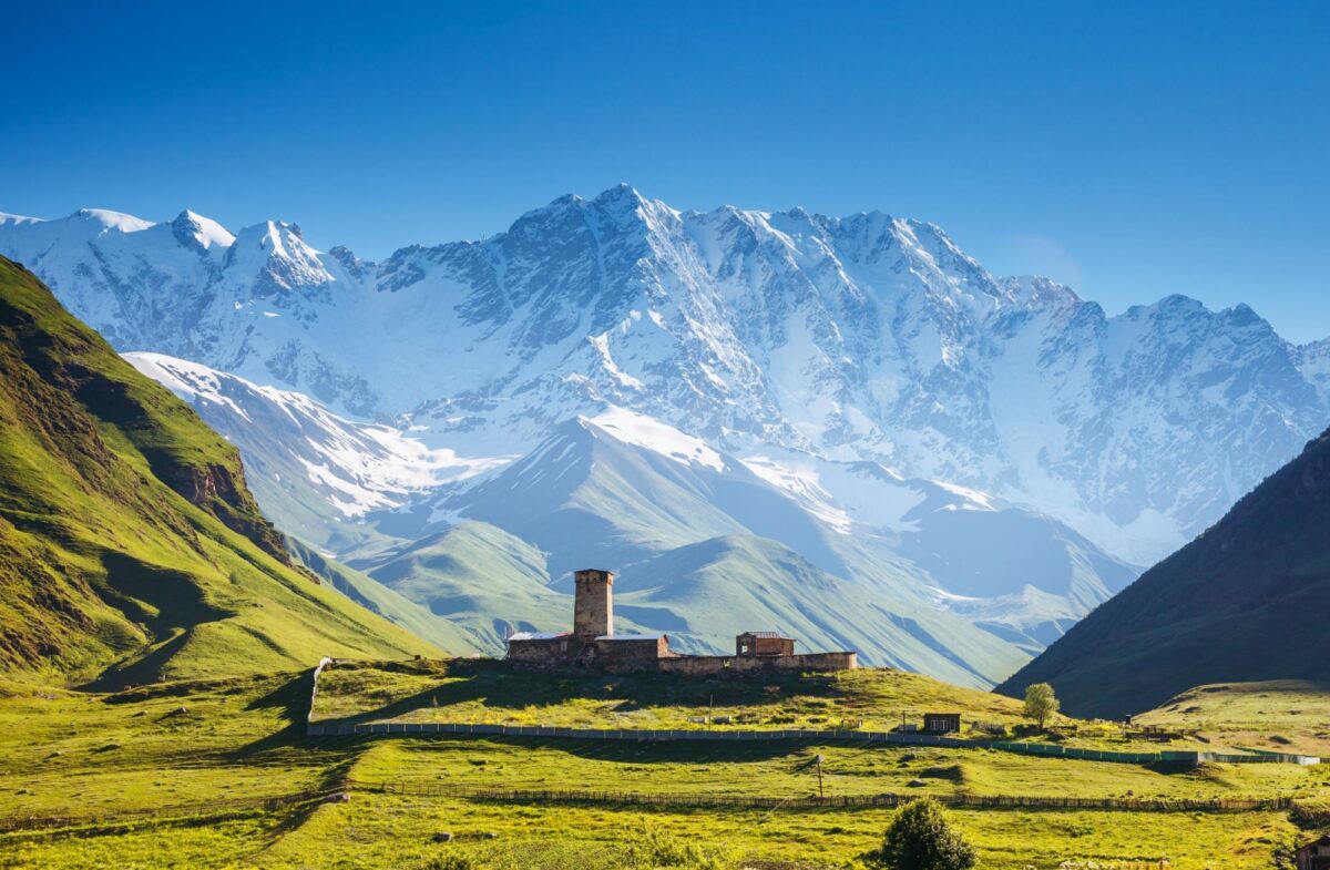
Classic Georgian scenery in Ushguli, Upper Svaneti UNESCO World Heritage Site
Georgia hiking: Need to know
Everything you wish you knew before you booked
DIY hiking vs organised walking holidays
There are two basic categories of hiking and walking holidays in Georgia: a DIY trip or an organised walking tour.
Georgia is a relatively easy country for solo hiking. You will be responsible for your own accommodation bookings, transport, and any necessary equipment. I suggest sticking with popular treks instead of hiking lesser-known areas when travelling solo. Wild camping is common and sometimes the only option, depending on the trek. More popular areas are well-connected with public transport, and logistics became an issue with places with less tourist infrastructure.
Organised walking holidays in Georgia come in two flavours: guided point-to-point treks, where you're escorted with a guide and stay in guesthouses or camping, or centre-based trips - you move from place to place and do guided day/short hikes. There are some self-guided walking holidays in Georgia but they're not very common yet.
Georgia hiking FAQs
Your questions, our expert answers
Question
When is the best time to go hiking in Georgia?
Answer
For most mountainous regions, the hiking season runs from May/June to September, with peak times in July and August. If the trail allows, I prefer early summer or autumn, with milder weather and still warm and long days.
Question
Are hiking trails waymarked in Georgia?
Answer
Some hiking trails are waymarked on rocks and trees, even in remote areas. Some trails also have actual trekking signs pointing the way and giving distances. These are very useful, but I suggest having another navigation tool, an offline map app, or a GPS tracker. I always have Maps.me and Mapy.cz apps installed on my phone.
Question
Is walking in rural Georgia safe?
Answer
Georgia is generally safe for visitors, as is hiking in rural areas – with all the obvious precautions.
The mountain rescue system is being developed, and remote regions have spotty, sometimes no, mobile coverage.
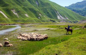
Avoid hiking alone in remote locations. Always keep an eye out for flocks of sheep, as the shepherds and their dogs guard them. When you spot one, call out 'gamarjoba' (hello in Georgian) for the shepherd to keep the dogs at bay.
Stay on the marked trails in border regions like Svaneti, Tusheti, and Racha.
There are bears but you're not likely to encounter much wildlife; they are usually shy and try to avoid humans as much as possible.
Question
What sort of accommodation should I expect?
Answer
Most towns and villages have guesthouses and homestays available on the major online booking platforms.
Georgians are pretty hospitable, so even if you get stuck in a village and miss the last marshrutka, they'll try to find you accommodation on the spot.
National park huts/refuges can't be booked online, but you can call the visitor centre and inquire about availability.
read more

Walking holidays in Armenia
I've been hiking in Armenia for years, visiting as a guidebook writer and travel journalist…

Caucasus trekking & hiking
With epic mountain landscapes that rival anywhere in Europe, fairytale villages, rolling hills and some truly excellent cuisine, the Caucasus mountains are one of the world's best – and most underrated – trekking and hiking destinations…