Walking holidays in Armenia
An expert guide to the best hikes in Armenia
I've been hiking in Armenia for years, visiting as a guidebook writer and travel journalist. With its stunning mountains, sweeping valleys and historic churches dating back to the fourth century, I think Armenia is one of the world's most underrated places for a walking holiday.
Squished between Georgia, Turkey, Azerbaijan and Iran, Armenia might be tiny – it’s eight times smaller than the United Kingdom – but the country has a diverse landscape with plenty of walking holidays for all levels. You can hike from village to village through forests of fruit trees, climb stark Caucasus mountains and visit traditional towns where the way of life hasn’t changed much in centuries. Beginners and those looking for short day hikes will enjoy the multitude of day hikes surrounding picturesque towns and there are multi-day treks for more experienced visitors.
Here's my essential guide on the best walking holidays in Armenia.
Walking holidays in Armenia: Overview
Underrated: Most Armenia walking itineraries feature the best-sellers: Yerevan, Dilijan National Park and Lake Sevan, and maybe a detour to climb Mt Aragats. These are all great, but if you've got longer try to check out some of the country's real hidden gems such as the Syunik region or the Gegham Mountains.
Logistics: Self-guided walking holidays aren't really a thing in Armenia; you can either book onto a guided/escorted tour, or DIY backpacking trips are feasible. Wild camping is usually permitted, with permission.
When to go: Your can hike most places from May to September, but my favourite time to visit is spring for the wildflowers or the autumn/fall when the fruit trees are ripe for plucking.
The best hikes in Armenia
The experts' top-rated walking holidays in Armenia
-
Mount Aragats from Lake Kari
-

Trek the Gegham Mountains
Trekking and camping expedition to Armenia'a hidden gems
Probably my top recommendation for an Armenia walking holiday is the 50km Gegham Mountain trail which takes three to four days of remote trekking featuring glorious alpine meadows, crater lakes, ancient petroglyphs and volcanic peaks, including Mt Azhdahak... -

Mount Khustup ascent
Crowd free summit climb
-

Transcaucasian Trail in Armenia
-

Selim to Ughedzor
-

Kachardzan to Hovk trek
-

Parz Lake day hike
-

Tatev day hikes
-

Matosavank & Jukhtavank loop
-

Artabuynk to Yeghegis
-

Kasagh Gorge hike


featured Armenia hikes
Guided Armenia Walking Holiday
10-day itinerary to Armenia's best hiking spots
10 days €1,380 – €1,540 pp

Mt Aragats Trekking Tour
Conquer the southern and the northern peaks of Aragats
3 days From $677 pp

Armenia & Georgia Walking Holiday
11-day guided hiking tour on picture-perfect mountain trails
11 days From $2,614 ppfeatured Armenia hikes
Guided Armenia Walking Holiday
10-day itinerary to Armenia's best hiking spots
10 daysFrom €1,380
Mt Aragats Trekking Tour
Conquer the southern and the northern peaks of Aragats
3 daysFrom $677
Trek the Gegham Mountains
Trekking and camping expedition to Armenia'a hidden gems
6 daysFrom $0
Armenia & Georgia Walking Holiday
11-day guided hiking tour on picture-perfect mountain trails
11 daysFrom $2,614Where to go hiking and walking in Armenia
Popular hiking spots and hidden gems

Armenia
Mount Aragats
Armenia’s borders might no longer contain Mount Ararat, the country’s national monument said to be where Noah’s ark first landed, but it does have Mount Aragats, a beautiful mountain in its own right and modern Armenia’s tallest peak. On Mount Aragats you’ll find waterfalls, sheep-covered valleys and pristine snow-capped mountains. To avoid the coldest temperatures, climbing is best between July and September, but don’t be surprised if there’s snow well into August.
How to get to Mount Aragats
There’s no public transport to Mount Aragats, so you’ll have to get to Kari Lake via taxi from Yerevan (about 10,000 drams) or by renting a car. The drive is 84km and takes about an hour and a half.
Many choose to get to Mount Aragats by hitchhiking, especially on weekends in the summer, but while hitchhiking is a popular way to get around in Armenia it's not recommended as it involves inherent dangers.

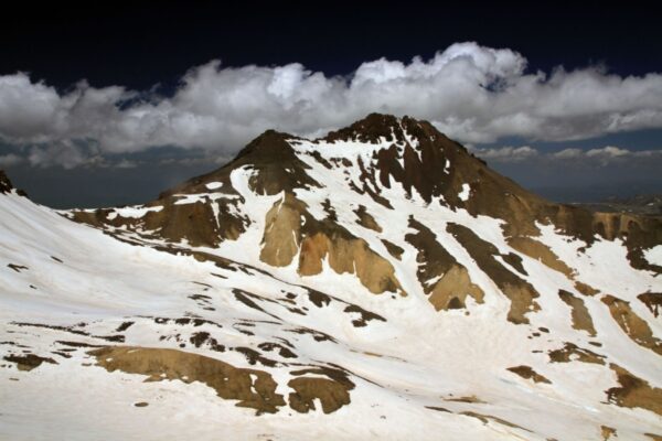
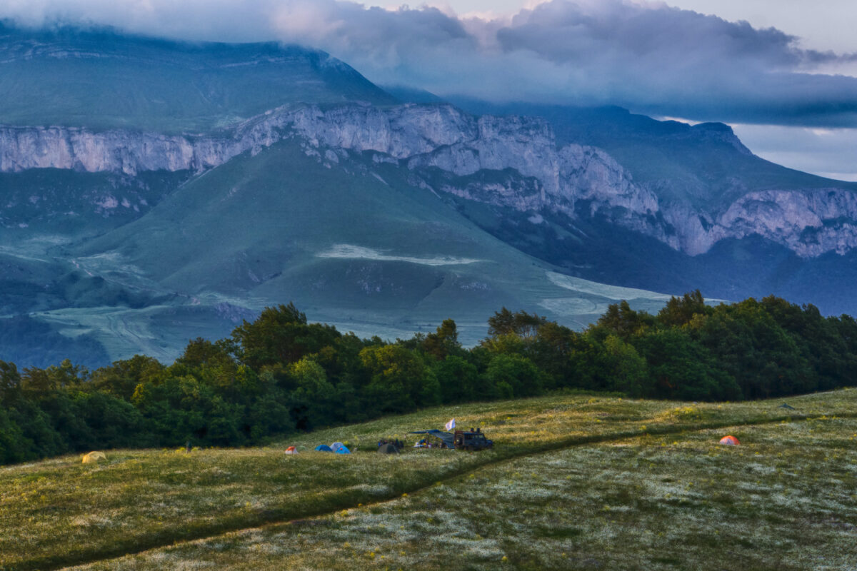
Gegham Mountains
Gegham Mountains
The Gegham Mountains, immediately between Yerevan to the west and Lake Sevan to the east, are a dramatic chain of hills and volcanic peaks that are almost entirely untouched by tourism.
The Geghams are largely impassible over the winter months, but in the summer there's probably nowhere better to go hiking or walking in Armenia. Most hiking trips here focus on Mt Azhdahak, and are run as camping expeditions, possibly with 4WD support. In addition to scaling Azhdahak you'll see some glorious snowmelt lakes (Vishapalich is a gem), some interesting prehistoric petroglyphs, and maybe nomadic herders bringing their cattle to graze.
I have personally developed and pioneered the "Gegham Mountain trail," a 50km hiking route which takes three to four days of remote trekking through the region's glorious alpine meadows, snowmelt lakes, prehistoric petroglyphs and – a highlight for most – scaling Mt Azhdahak.
Read more
Armenia
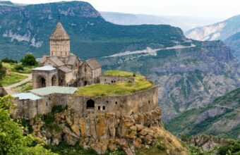
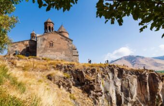
Tatev Monastery
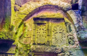
Since as far back as the 9th century, Tatev Monastery in the south of Armenia has commanded a bold place overlooking one of Armenia's most epic sights, the Vorotan Gorge, which dips 800m beneath stark cliffs. The gorge is a sublime destination for day hikes with trails leading to tiny villages and important cultural sights.
How to get to Tatev
There are no marshrutky (minibuses) to Tatev or Halidzor from Yerevan, but you can take one to nearby Goris and then onto Tatev from there. Marshrutky leave Yerevan’s Sasuntsi Davit metro station for Goris at 9am and 4pm and take about six hours (2500 drams). From Goris, minibuses leave for Tatev at 8:30am and 3:30pm from the bus stop on Komitas St and take an hour.
There are shared taxis from Yerevan to Halidzor, but not to Tatev. Ask at your accommodation in Yerevan to have one pick you up. A private taxi from Goris should cost 8000 drams.
The drive from Yerevan is 250km and takes about five hours.

Armenia
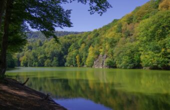
Dilijan National Park
Known as the ’Switzerland of Armenia,’ Dilijan National Park is a mountainous area covering 240 square kilometres with some of the best and most care-free hiking in the country.
You’ll find beech and oak forests populated with brown bears, wolves, deer and eagles as well as an abundance of fresh fruit including apricots and berries. The town of Dilijan is a wonderful place to recharge in between hikes with plenty of quality accommodation and delicious restaurants.
How to get to Dilijan National Park
You can take a marshrutka (minibus) from the Hyusisayin Avtokayan station in the north of Yerevan between 9am and 6pm. Minibuses leave when full and take about two hours to get to the central roundabout in Dilijan. The cost of the trip is about 1000 Armenian drams.
A taxi from Yerevan to Dilijan could cost up to 14,000 drams for the 100km journey.
When in Dilijan, there are plenty of taxis that can take you to surrounding towns or to your accommodation, though the town is quite small so it’s easy to walk around.
If you’d prefer to drive, there are several rental car agencies at the airport in Yerevan and it’s an easy drive along the M4 highway.

Armenia
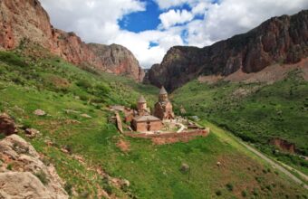
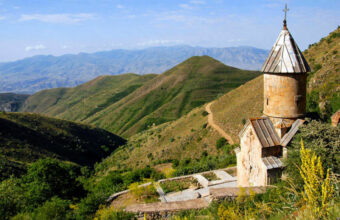
Yeghegis Valley
Surrounded by huge peaks, charming villages, medieval churches and roaming animals, the Yeghegis Valley in Armenia’s Vayots Dzor province is excellent hiking territory. Don’t believe me? Take it from the Silk Road merchants who passed through here on their way to and from Western Europe and Asia. You can still find evidence of their journeys with a well-kept 14th-century caravanserai (shelter for weary travellers) in the Selim Pass. Summers in this region can get very hot at midday, so hiking between May and June or October and November is ideal.
How to get to the Yeghegis Valley
Buses leave Yerevan from the Sasuntsi Davit train station in the morning for Yeghegnadzor, the area’s main hub, and take about two hours (AMD1200). From there, you’ll need to take a taxi up to Artabuynk or the Selim caravanserai, which costs the standard AMD100 per kilometre rate.
A taxi from Yerevan to Yeghegnadzor costs about 15,000 drams and takes two and a half hours.
Driving is a good idea as there’s plenty to explore in the region but few buses to take you there. However, keep in mind that if you’re planning to do the Artabuynk to Yeghegis or Selim to Ughedzor hikes they aren’t loops, so you’ll have to find your way back to where your car is parked.

Armenia
Ashtarak and Kasagh Gorge
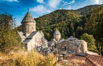
In the Western Armenian province of Aragatsotn, the massive Kasagh Gorge is overlooked by not one, but two of Armenia’s most striking monasteries; Saghmosavank, which was built in the 13th century and Hovhannavank, which dates back to the 5th century.
How to get to Kasagh Gorge
Ashtarak is very easy to get to from Yerevan. Marshrutky (minibuses) leave from the Kilkya Avtokayan bus station every twenty minutes between 8am and 8pm and take 40 minutes (250 drams). To get to the Kasagh Gorge you’ll need to drive, hitchhike or walk — Hovhannavank is 7km from the centre of town.
Ashtarak is just 30 minutes from Yerevan by car or taxi. GG and Yandex, Armenia’s equivalent to Uber and Lyft, will have the best rates.

Armenia
Syunik region
In the Syunik region, in southern Armenia, there are some fascinating abandoned villages such as Hin Khot and Hin Shinuhayr, which are connected by a newly-discovered 10km trail. Virtually no other tourists come this way and it's perfect hiking country among beautiful landscapes. Nearby Goris town is a good launchpad for exploring the region.
Armenia's Dilijan National Park features highly on walking holiday itineraries
Hiking in Armenia: Need to know
Everything you wish you'd known before you booked
Armenia is a small country and so far we have been spared hyper-development of the mass tourism industry. This means despite its small size, there is a lot that hasn’t been “discovered” by the mainstream travel industry. Most hiking itineraries offered by the international walking holiday operators focus on the best-sellers: Yerevan, Dilijan National Park and Lake Sevan. These are all great but with a little extra effort there’s so much more to see here.
In the Syunik region, in southern Armenia, there are the fascinating abandoned villages of Hin Khot and Hin Shinuhayr, which are connected by a 10km trail. Just north of Yerevan there is an excellent 6.5km loop around the Aparan Reservoir overlooked by a 4th-century church.
But probably my top recommendation for an Armenia hiking trip is the 50km Geghama Mountain trail which takes three to four days of remote trekking that features incredible alpine meadows, extinct volcanoes, crater lakes and ancient petroglyphs. The only other people you’ll see out here are a few like-minded travellers and shepherds. This is a camping trek with complex logistics, so is rarely offered by international trekking or walking holiday companies.
The best time to hike in Armenia is during the spring when millions of wildflowers blanket the valleys or in the fall when fruit trees including fig and apricot (a fruit so prized Armenia put its colour on the flag) are ripe for plucking. Winters in Armenia can be freezing cold and mountaintop trails will be covered in snow.
Wear boots and long pants on trails across the country as Armenia is home to 22 species of snakes including four vipers. You should also avoid hiking near the eastern border with Azerbaijan as an active conflict over the disputed territory of Nagorno-Karabakh can bubble up at any moment.
Walking holidays vs solo hiking
Armenia is a popular destination for organised multi-day walking holidays, of which there are two types: point-to-point treks such as the Transcaucasian Trail (or segments of it), and centre-based walking holidays where you'll move from place to place by road and do day hikes in each location.
Both types are typically escorted with a guide in a small group tour, although private or self-guided tours may be available. Included in the price will be your pre-booked accommodation, ground transfers, and guided excursions.
If you're travelling independently it's generally fine to set up camp nearly wherever you want as Armenia has few restrictions on camping except in a few designated reserves and on private property. If you want to camp on someone’s land, of course ask for permission first. Don’t be surprised if the owner not only gives you permission, but invites you inside for a dinner of khoravats (barbecue meat skewers) with lavash (traditional thin bread) and a shot of oghee (fruit vodka).
Armenians are very proud of their country, their culture, their food and their mountain spring water, which you can generally drink safely throughout the country.
Armenia hiking FAQs
Your questions, our expert answers
Question
Best walking holiday in July?
Where would you suggest for an Armenia walking holiday in July – ideally quiet or off the beaten path?
Answer
As July can be quite hot, I'd suggest a centre based trip to Dilijan National Park, where the forests will keep you cool. Otherwise if you want a camping experience, the Geghama mountains trail is a top highlight, very remote and quiet.