


Sandakphu trek itinerary
Climbing the highest peak in West Bengal
- Difficulty: Moderate
- Distance: 49 km
- Duration: Six days
- Start/end point: Mane Bhanjang to Srikhola, West Bengal
- Accommodation: Homestays
They say that from Sandakphu Top – the highest peak in West Bengal – the Kanchenjunga mountain range resembles the outline of a sleeping Buddha. I couldn’t quite see the resemblance myself but after three days slogging along the India-Nepal border (often unknowingly crossing between one and the other), it really didn’t matter. I would have done anything for the sunrise view that makes this one of the highest-demand treks in this part of the Indian Himalaya.
Sandakphu, meaning "height of the poisonous plant" in the local Lepcha language, got its name from the toxic Indian aconite plant that thrives here. Visiting in March, I was fortunate to see rhododendron trees blooming vibrantly in red, pink, white, and purple. However, I wasn't as lucky spotting the elusive red pandas, which are known to live hidden within the forests of Singalila National Park.
Key information
| Destinations | West Bengal |
|---|---|
| Activity | Adventure, Backpacking, Trekking, Active, Walking, Nature & Wildlife, Responsible Travel, Slow Travel |
| October - April |
Sandakphu trek itinerary itinerary
NJP Railway Station to Mane Bhanjang
Day 1 in Siliguri
I arrived at NJP Railway Station in Siliguri, but you can arrive at Siliguri's Bagdogra Airport as well. From here I travelled by shared car to Mane Bhanjang, a small village located on the India-Nepal border. On the way we passed Mahananda Wildlife Sanctuary, where I’ve heard you can spot deer or elephants although we were not so lucky. The road climbs, winding through the towns of Kurseong and Ghoom along the way. The iconic railway of the Darjeeling Toy Train follows the road, which we caught sight of clanking along beside us.
We spent the night in a simple homestay in Mane Bhanjang.
Mane Bhanjang to Tumling
Day 2 in Mane Bhanjang
Distance: 11km
Max Elevation: 2970 meters
The hiking begins on day two, taking us from Mane Bhanjang to Tumling, passing through Chitrey, Lamedhura, and Meghma. The hike started with a steep ascent on stone-paved trails, climbing through picturesque forests. At Chitrey we found a classic Himalaya scene of white stupas and colourful prayer flags fluttering in the wind. From here we hiked through the hamlets of Lamedhura and Meghma backdropped with stunning panoramic views. After five hours of walking we reached the village of Tumling. A clear sky offered us spectacular views of the Kanchenjunga range below the Milky Way stretching across the horizon – truly one of the most incredible things I've ever seen.
Tumling to Kalipokhri
Day 3 in Tumling
Distance: 15 km
Max Elevation: 3169 meters
The next morning we started hiking on the rocky and uneven trail from Tumling, slowly heading towards our next mini-halt, Gairibas. After Gairibas the trail turned into an arduous uphill climb up to Kaiyakata, gaining higher altitude. Afterwards, we meandered through rhododendron forests and traditional villages like Batasia, with occasional mist in the air. After five hours of hiking, the trail at last started to open up. That night we slept in a homestay by this region’s darkest water-lake, Kalipokhri, a locally revered sight with deep religious significance.
Kalipokhri to Sandakphu Top
Day 4 in Sandakphu
Distance: 7 km
Max Elevation: 3636 meters
The steepest and most challenging climb on the Sandakphu trek is from Kalipokhri to Sandakphu Top, but the blooming rhododendrons and snow-covered mountain peaks in the distance made the difficult ascent just about achievable. Along the trail, thickets of bamboo and pine forests had sprawled around Sherpa villages, where we were welcomed with steaming tea. Once we reached the top, we finally witnessed the orange sunset against the mighty Himalayan Range and the so-called sleeping Buddha I had heard so much about – squint and you can just about see it!
Sandakphu Top to Srikhola
Day 5 in Srikhola
Distance: 17 km
Max Elevation: 3636 meters
From Sandakphu to Srikhola the trail was a generously gentle and winding descent straight to Gurdum village on a dirt trail and reaching the Srikhola River we crossed over some wooden suspension bridges. After around seven hours we were down in Srikhola and ready for our beds in a local homestay.
(From here you can choose to extend the hike with an extra stretch of ‘Sandakphu to Phalut’ for another two to three days. If you are up for it, take the detour from Sandakphu Top to Gorkhey that eventually leads to Phalut.)
Srikhola to NJP
Day 6 in Siliguri
Distance: 90 km
It was time to wave goodbye to the serene Singalila National Park and take the ride back to New Jalpaiguri. Shared SUVs, easily available at Srikhola, dropped us off at NJP Railway Station after around a seven hour drive.
Need to know
When to go
Peak season for the Sandakphu trek is between October and November, the pre-winter period with the best views of the four gigantic Himalayan peaks.
Once December rolls in, up till February, the harsh winter and foggy trail heads can drop down to -10°C at night. Some homestays might be closed over this period.
March to April is the season for blooming rhododendrons, orchards and Magnolias.
The trail is officially closed for the monsoon period between June and September.
Getting there/around
I landed in NJP Railway Station, but if you are planning to fly, the nearest airport is Siliguri Bagdogra Airport, 84 km away from Manebhanjyang. Transportation from both the airport and railway station is readily available using on-demand shared cars.
There is an option to hire a landrover to Sandakphu Top from Manebhanjyang, but I’d encourage you to hike unless you’re physically challenged. We don’t need more trucks tearing up and down the last remnants of our peaceful world.
How to do it
It is mandatory to hike with a trekking guide. This was possibly my only hesitation; as a solo and independent hiker, I’m much happier trekking alone. But these guides give you a great local dimension to your visit and are very helpful in arranging your overnight stay in the homestays.
To find your trekking guide, just ask around in Manebhanjyang. Porters are also available for hire.
Permits
You will need three separate permits along the way. Get your first permit from Forest Eco-Tourism at Manebhanjyang, again at Tumling and then again at Kalipokhri.
Other itineraries you might like

Classic Everest Base Camp route
16 day Everest Base Camp trek itinerary
Approx. 16 days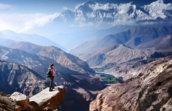
Upper Mustang trek to the Walled City
A trek through Nepal’s restricted Tibetan side
Approx. 14 days
Helambu & Langtang Trek
Crowd-free trekking on Kathmandu’s doorstep
Approx. 16 days

