


Hampta Pass Trek
Following old shepherd routes in Himachal Pradesh
This trek in Himachal Pradesh state was once a traditional route for Gaddi shepherds to relocate their flocks from Lahaul Valley into Kullu Valley, via the 4,277 metre Hampta Pass which connects these two starkly diverse landscapes and gives the trek its name.
As I pressed on through my journey, through steep ascents, fast-flowing river crossings and craggy trails, I got to experience for myself the transition from the pale-green meadows of Kullu to the semi-desert landscape of Lahaul.
A note of caution: unregulated tourism is taking its toll in this area, as with much of the Indian Himalaya. What was once a remote trading route for shepherds to barter barley, potato and wool is now under great pressure from littering and irresponsible camping. If you come here, please ensure you visit respectfully and responsibly.
Key information
| Destinations | Himachal Pradesh |
|---|---|
| Activity | Adventure, Backpacking, Trekking, Active, Walking, Camping, Responsible Travel, Slow Travel |
| June - September |
Hampta Pass Trek itinerary
Manali to Chika
Day 1 in Manali
Distance: 18-20 km drive, 6 km hike
Max Elevation: 3,100 m
I hitchhiked from the bustling hill town of Manali to Jobri (shared cabs are also available), navigating winding mountain roads. Jobri, the starting point of the Hampta Pass trek, features a few scattered dhabas (simple roadside eateries) that soon disappear as you hike towards Chika, following a narrow river for the next three hours. My waterproof hiking boots proved invaluable during the route’s first river crossing just before reaching Chika.
That night, I pitched my tent by the riverside and enjoyed a restful sleep in Chika.
Chika to Ballu ka Ghera
Day 2 in Chika
Distance: 8 km
Max Elevation: 3,600 m
After packing up my tent and grabbing my hiking poles, I followed trail markers painted on stones and trees. The green valley gradually ascended, requiring careful footing on slippery rocks and watery patches. Within the first three hours, the river became stronger, making another river crossing unavoidable, often assisted by locals with harnesses, particularly after 4 pm due to heavy water flow. From here I faced another four hours of challenging uphill hiking before reaching Ballu ka Ghera, the coldest campsite along the route.
Ballu ka Ghera to Shea Goru via Hampta Pass
Day 3 in Ballu ka Ghera
Distance: 9 km
Max Elevation: 4,270m
The trek becomes significantly more difficult on the way to Hampta Pass, at 4,277 metres (14,035 feet). Packing food and water from the canteen at Ballu ka Ghera, I hit the rocky, moraine-filled terrain while taking in views of the snow-capped Mt. Hanuman Tibba and approaching glaciers. Hampta Pass itself is narrow, surrounded by steep cliffs and ridges, with lingering snow patches and glacial streams splitting around the pass. Adding an extra layer of warmth even in June, I carefully descended to Shea Goru, the first campsite in the Lahaul Valley, for another night under the stars.
Shea Goru to Chhatru
Day 4 in Shea Goru
Distance: 7 km
Max Elevation: 3,300m
Although the temperature had dropped below zero at Shea Goru the previous night, the weather quickly returned to a pleasant summer warmth. Given the unpredictability of high-altitude Himalayan conditions, you need to be prepared for sudden weather changes. Fortunately, the most challenging ascent was now behind me, and within four hours, I reached Chhatru, a small cluster of dhabas nestled among Lahaul’s rugged brown mountains. I pitched my tent near one of the eateries and experienced a stunning night of stargazing under Lahaul-Spiti’s crystal-clear skies.
Chhatru to Manali
Day 5 in Chhatru
Distance: 60 km
Max Elevation: 3,300m
The Hampta Pass Trek concludes at Chhatru, and the onward journey is your call. Before taking the bus back to Manali, you have the option of hiring a shared cab to visit Chandratal Lake, a stunning crescent-shaped high-altitude "Moon Lake" at 4,270m. There are designated camp sites equipped with Swiss tents and basic facilities. From there, you can either return directly to Manali or spend the night by the lake.
Hampta Pass Trek: Need to know
When to do the Hampta Pass trek
There’s a four-month window between June and September to tackle the Hampta Pass Trek, each month with its own merits.
I hiked in June, freshly green right after winter, with higher altitude areas around Hampta Pass still under thick snow, and the water level in the river relatively low.
Around July and August, the lushness of the green meadows meets wildflowers in full bloom in Kullu Valley, while Lahaul’s dryness remains the same. Now over time, with the thawing of glaciers, the river crossings become trickier, but definitely more adventurous.
September is most lively, with picture-perfect blue skies at the end of monsoon, but expect more crowds.
Getting there & around
Himachal is well-connected by local buses and shared cabs. Plenty of buses and cabs run from Manali on a daily basis. Every day one bus leaves for Kaza from Manali and another bus makes the reverse trip. You can board that bus from Chhatru to return to Manali on your last day of hiking.
Need to know
The most important thing to know is that there are no homestays on the route. Either your trekking company will arrange for your tent or if you are hiking independently, you need to bring your own camping gear and supplies. Food is usually available in canteens, subject to weather disruptions – I’d advise you bring enough dehydrated meals for backup.
If you are a solo and independent hiker, make sure to follow the arrowheads, which can be a little confusing on days three and four, but should be navigable if you are vigilant. Or else always follow the river flow that trickles down from the Pass.
Permits for both trekking and camping must be obtained from the forest department office in Manali since the trail passes through the Pir Panjal Range.
Other itineraries you might like

Classic Everest Base Camp route
16 day Everest Base Camp trek itinerary
Approx. 16 days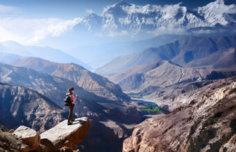
Upper Mustang trek to the Walled City
A trek through Nepal’s restricted Tibetan side
Approx. 14 days
Helambu & Langtang Trek
Crowd-free trekking on Kathmandu’s doorstep
Approx. 16 days

