


Sherpa Expeditions [Walker's Britain] organised my recent self-guided Coast to Coast trek All the arrangements went seamlessly, and the route notes and maps provided were extremely comprehensive and tailored to my itinerary. All my pre-departure questions were answered promptly and to my satisfaction. I absolutely recommend Walker's Britain and I will be using them again in the future. Thank you so much!
Northern Ireland's Best Walks
Northern Ireland's top walking holidays and routes
Northern Ireland’s walking trails crest mountain peaks, wind through remote moorland and cross empty beaches. They take in picturesque ruined castles, thundering waterfalls and a coast so spectacular it features in the Game of Thrones. Routes range from challenging multi-day treks to relaxing day hikes. Rest days might see you horse riding beside the shore, trying a spot of surfing or soaking in seaweed baths. And as you walk you’re also exploring Northern Ireland’s character—insights into faith, history and culture are revealed with each step.
Best walking holidays in Northern Ireland
Saint Patrick's Way
The wealth of environments encountered on the 82-mile Saint Patrick’s Way reveal rich insights into Northern Ireland’s culture and complexities. History and faith are writ large on the landscapes here; hiking through them emphasises how the mountains, forests and coast have shaped the people and places you encounter today.
Walking the Saint Patrick’s Way sees you hiking from history-rich city streets to mountain foothills via canal paths, woods and sand dunes. Although winding through wild places, the sign-posted route is easy to access and has plenty of spa hotels, B&Bs and inns. It’s best experienced from mid-spring to autumn.
Distance: 82 miles/132km
Duration: Six to 10 days
Start point: Armagh City, Armagh
End point: Downpatrick, County Down
Difficulty: Moderate to easy. A well marked route along on- and off-road trails, through diverse terrain
Suitable for: Fit walkers; families with older children; pilgrims
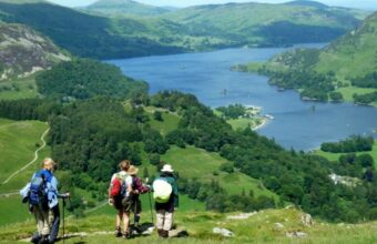
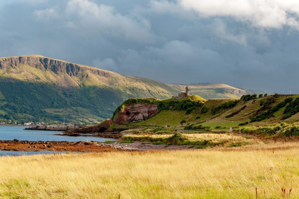
The view of Warrenpoint from St Patrick's Way in the Mourne Mountains
Saint Patrick’s Way sections
Day 1 - Navan Fort, via Armagh City to Scarva (22 miles/35km)
Start at intriguing Navan Fort, where a recreated Iron Age village brings the past vividly to life. Next hike via country roads to the canal-side town of Scarva. You can turn this stretch into two legs (of 3 miles/5km and 18 miles/30km), by spending a day and night exploring the cathedral city of Armagh.
Day 2 - Scarva to Newry (12 miles/20km)
The Newry Canal’s level towpaths lead you to the border town of Newry. You’ll pass the villages of Poyntz Pass and Jerrettspass - the “pass” in their names signals their historic role of providing vital routes through the surrounding bogs.
Day 3 - Newry to Rostrevor (9 miles/15km)
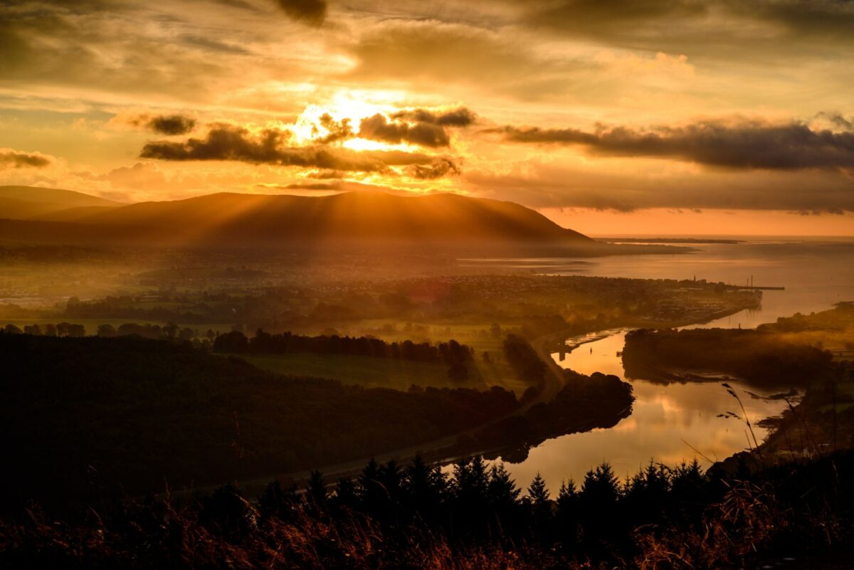
A day of shifting scenery - from canal paths to views of the Mourne Mountains and the coast. Edge the beach at Warrenpoint before arriving at the Edwardian seaside resort of Rostrevor.
Day 4 - Rostrevor to Spelga Dam - 11 miles/18km
Next head into a landscape that inspired Narnia writer, CS Lewis, who spent his holidays in Rostrevor as a boy. Forests meet the foothills of the Mourne Mountains en route to the scenic Spelga Dam. There aren’t many places to stay around the dam, hikers often ask B&Bs in Newcastle for a pick-up/drop off service instead.
Day 5 Spelga Dam To Newcastle 12 miles/20km
Time to skirt the granite tors of towering Slieve Bearnagh, one of the highest of the Mourne Mountains. Then it’s onto seaside Newcastle, a Victorian resort wedged between Slieve Donard, Northern Ireland’s highest peak, and golden sands. Newcastle is also home to the Soak Seaweed Baths.
Day 6 Newcastle to Tyrella (11 miles/18km)
Views of coast and hills frame your walk today. Sand dunes, mudflats and nature reserves come with chances to spot a wealth of wading birds. You may also be able to saddle up at the Mount Pleasant Riding & Trekking Centre. The village of Dundrum, with its ruined castle, is an appealing place to stay.
Day 7 Tyrella to Downpatrick (10 miles/16km)
The final leg of your multi-day walk leads inland, along rural roads into ‘Saint Patrick’s Country’, so called because the saint brought his boat ashore at nearby Strangford Lough. The trail ends at Downpatrick Cathedral, Saint Patrick’s final resting place, an impressive 82 miles after the start.
Why rush?
Consider taking your time over the Saint Patrick’s Way. Factoring in rest days means you can delve deeper into the local culture and enjoy some non-hiking activities such as sampling Armagh’s famously good artisan cider, to heading out horseback riding, and soaking in seaweed baths.
The Mourne Mountains
The Mourne Mountains offer some excellent hiking. Looming large on the horizon, they’re Northern Ireland’s highest hills and are topped by exposed granite rock formations called tors. Away from the summits, gorse-smothered slopes are criss-crossed by a network of dry stone walls. Tucked into the very south east of Northern Ireland, they’re best accessed from the Victorian seaside resort of Newcastle. It’s backed by a long strip of sandy beach and has plenty of places to stay and eat.
While there are plenty of peaks, it is also possible to skirt the high ridges and focus on the foothills. Confident navigators will be comfortable taking on the more remote routes, those with less experience may prefer to join forces with one of the local walking providers. Taxis are used to ferrying walkers between accommodation and trails. Local tourist offices will have the latest information on the Mourne International Walking Festival and special walkers’ bus services. The Mourne Mountains website (www.visitmournemountains.co.uk) is full of useful information.
Distance: Various day hikes
Difficulty: Moderate to hard
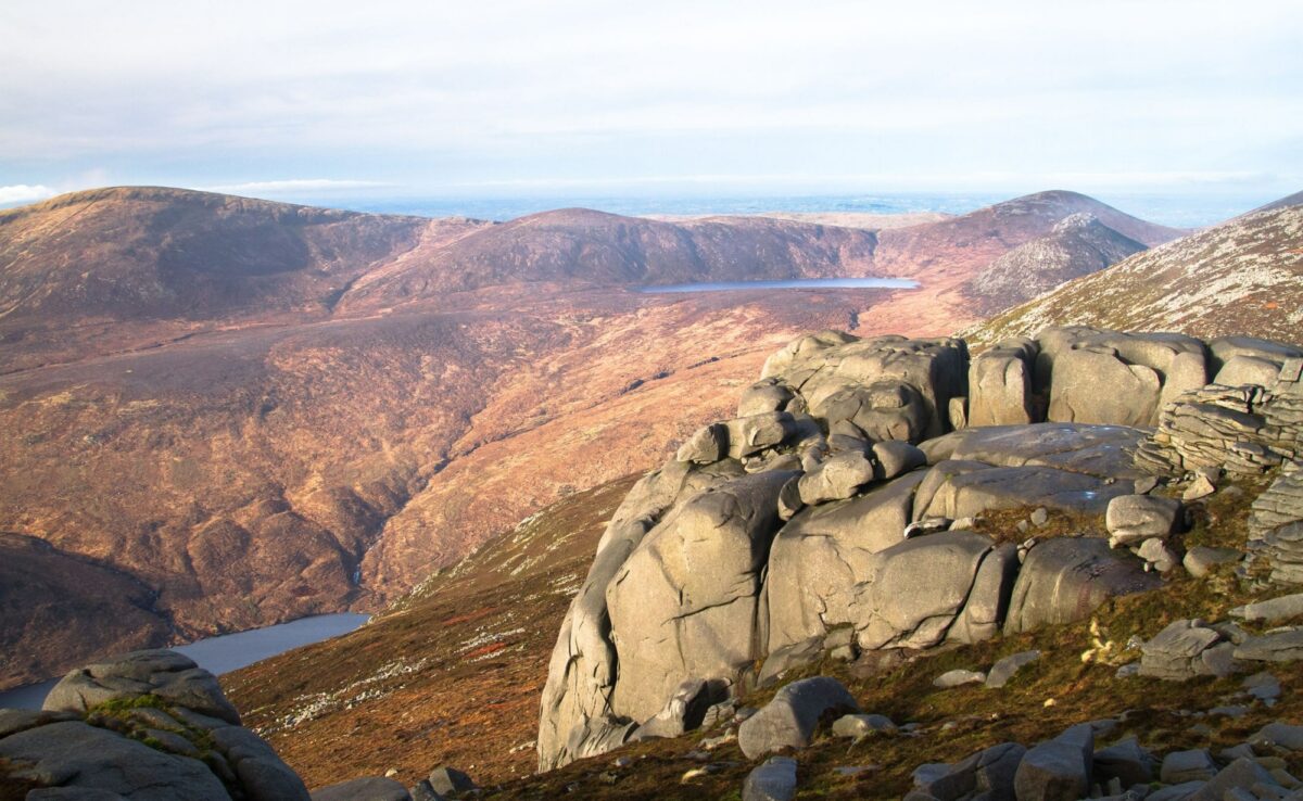
Slieve Binnian, in the Mourne Mountains, County Down
Suggested day hikes
Slieve Donard, Commedagh & Bearnagh
Your chance to climb three of the four highest Mournes in one day, as you take in Slieve Donard (853m), Slieve Commedagh (765m) and Slieve Bearnagh (739m). It’s a tough, steep route, that clocks up 11 miles/18km and offers views sweeping from the cresting peaks of the Mournes to the sea.
Slieve Binnian
At 747m Slieve Binnian is the third highest of the Mournes, and this 7-mile/11km, circular route is as memorable as you’d expect. It follows the drystone Mourne Wall to the summit, providing views across glittering loughs to Dublin’s Wicklow Mountains and the Isle of Man.
Mourne Way
This two-day, 26-mile/42km, linear walk, cuts across the northern fringe of the mountain range, from Newcastle to Rostrevor. It’s largely off-road, on forest and mountain trails and has no waymarking. The route provides insights into the Mournes’ unique landscapes away from the big-name hills; the highest point here is 500m Butter Mountain.
Mourne Wall Challenge
The extraordinary, 22-mile/35km drystone wall that is the Mourne Wall powers up and along an impressive array of mountain peaks. It was built in the the early 20th-century to control livestock and today sweeps over 15 summits. Traditionally the circular route was walked in one day but, as it takes in seven of the Mourne’s 10 highest mountains, you may choose to complete it over two.
Smugglers’ Trails
In the 1700s gangs used the web of trails through the Mourne Mountains to smuggle in contraband, including tobacco, wine and spirits, dodging the taxes levied by the excise men at Newcastle. One of the smugglers’ routes, the Brandy Pad, is a popular hiking route today: you’ll walk part of it on the hike up Slieve Donard, Commedagh and Bearnagh.
Sliabh Beagh Way
Spanning the border between the counties of Tyrone, Monaghan and Fermanagh, Sliabh Beagh is an expanse of myth-rich rolling moorland. Although this three day trail sees you cresting drumlins and skirting blanket bog, the walking is mostly on rural roads and forest paths past fields, rivers and loughs.
Clear waymarkers and largely firm paths make this a series of fairly gentle hikes: the highest hills here are only around 380m. The route is at its best from spring to autumn. Relatively limited on-trail accommodation will probably see you booking taxis to shuttle between the middle sections and your hotel or B&B.
Distance: 41 miles/65km
Duration: Three days
Start point: Aughnacloy, County Tyrone
End point: Lisnaskea, County Fermanagh
Difficulty: Easy, on clearly marked, mainly firm paths and country roads.
Suitable for: Those who enjoy relaxed explorations, forests and moors.
Sliabh Beagh Way sections
Day 1 - Aughnacloy-Bragan - 13 miles/21km
From the town of Aughnacloy, you’ll cross the River Blackwater into the Republic of Ireland; the first of many border crossings. After sections through deciduous and pine forests, a five minute detour leads to Altadaven Glen; a magical, fern-packed glade that’s home to Saint Patrick's Chair. The massive throne has been carved out of moss-smothered boulders and is reputedly where Saint Patrick said mass. After skirting Lough More a series of lanes lead to the open moorland of Sliabh Beagh. Climb to the picnic area near Bragan, with it’s wrap around views it’s a fitting point to finish for the day
Day 2 - Bragan-Eshywulligan - 11 miles/18km
Open moorland starts the second leg, as you edge the exposed, rounded hill of Sliabh Beagh. The path leads beside an expanse of blanket bog scored with streams and drainage ditches and dotted with footbridges and loughs. Next comes Mullaghfad Forest and isolated Mullaghfad Church. Built in 1836, the church has never had electricity; look out for the external bell, visible at the crest of the roof. Next come more upland loughs - first, in quick succession Cushkeery and Jenkin, then Lough Nadarra. From here it’s a short stretch to the road marking the end of another day’s hike.
Day 3 - Eshywulligan-Lisnaskea - 16 miles/26km
Kick off the final leg with more expansive views and upland loughs. This time Lough Nabull, which sits within exposed peatlands, shortly followed by the trout-packed Lough Corry. More forests and lakes lead down, via views of Upper Lough Erne to rural roads and - eventually - the streets of Lisnaskea and the end of the Sliabh Beagh Way.
Biblical connections
The final day’s hike brings views of the rise of Carnmore. This hill is said to be the final resting place of Bith, son of Noah. Legend has it that when Noah set sail in the biblical flood, his son launched a second ship which came to rest on Carnmore Hill.
Causeway Coast Way
This path takes in the big sights on Northern Ireland’s blockbuster shore. You’ll encounter the mesmerising Giant’s Causeway, wobbly Carrick-a-Rede Rope Bridge and photogenic Dunluce Castle, as well as a clutch of Game of Thrones film locations. Inevitably the big-name sights get busy, but tucked in between are vast sandy beaches and stretches of uncrowded cliffs.
The Causeway Coast Way is geared up for visitors and has good accommodation, bus links and walking providers. You may want to get a bus or taxi from and to your accommodation at the half way point on the trail. It’s best to avoid school holidays, when crowds and prices peak; spring and September are ideal times to hike. You’ll want to factor in exactly when to walk the long White Park Bay section - low tide means you can stroll along the beach, high tide takes you along the A2 road. Local tourist offices (www.visitcausewaycoastandglens.com) can advise on any diversions and route changes.
Distance: 32 miles/51km
Duration: Two days
Start point: Portstewart, Derry
End point: Ballycastle, County Antrim
Difficulty: Moderate, with well-marked trails
Suitable for: Fit hikers; families; geographers; photographers
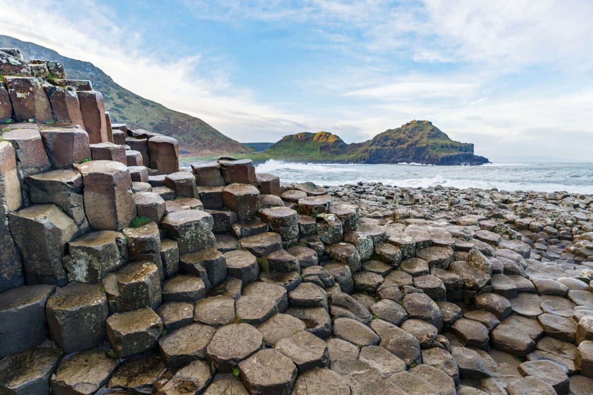
The famous basalt columns of the Giants Causeway
Causeway Coast Way sections
Day 1 - Portstewart-Giant’s Causeway - 14.6 miles/23.6km
You begin with a sandy beach; at the long stretch of Portstewart Strand. From there, the trail leads to the genteel golfing town of Portstewart itself, before heading over the headland to the seaside resort of Portrush. The next stretch brings another beach stroll and then a longer hike on pavements, still with sea views. It’s well worth taking the short detour to explore medieval Dunluce Castle, a dramatic, crumbling fortification that features in the Game of Thrones. After the village of Portballintrae comes an entirely off-road stretch which takes in sand dunes, boardwalks, footbridges and cliffs, and reveals views of the Giant’s Causeway. It gets more crowded as you near the causeway itself. It’s a genuinely striking sight - a multi-millennia old array of 40,000 interlinked hexagonal basalt columns that stretches out to sea. Explore the causeway and nearby Organ rock formation fully before climbing back up the cliff path. It’s a fitting point to pause - nearby places to stay include Bushmills, home to the famous Bushmills whiskey distillery, and Ballintoy. There are also plenty of options back in Portrush.
Day 2 - Giant’s Causeway-Ballycastle - 17.2 miles/27.7km
Start where you left off - the grass trail leads past the site of a Spanish Armada shipwreck, before going down to the ruins of Dunseverick Castle and onto Dunseverick Harbour, accompanied by cracking views of Rathlin Island. Your planning to cover this next section at low tide will hopefully pay off - low tide means you can scramble over rocks to walk along the 1.2-mile/2km stretch of sand at White Park Bay; high tide sees you shadowing the A2. After rock arches and sea stacks you’re at pretty Ballintoy Harbour, another Game of Thrones filming location. Crowds build again around the startling Carrick-a-Rede Rope Bridge; a thin, 20m-long wire rope bridge that spans a 30m drop to connect a tiny island to the shore. Distancing restrictions may mean the bridge is closed, if you can cross it, it’s a short and disconcerting but memorable walk. Next take the detour down Glenstaughey Road, to avoid part of a busy on-road section (although some walking beside the B15 is unavoidable) before you head into the seaside town of Ballycastle and the end of the trail.
Not all hiking
Although you can easily hike the Causeway Coast Way in two days, taking time out en route allows you to delve deeper into local history and culture. You’ll find food tours, surfing lessons, stand up paddle boarding sessions and riding stables, as well as a famously warm welcome in local pubs.
Antrim Glens
Basing a hiking holiday in this northern corner of Northern Ireland puts you in the heart of the Antrim Glens, a series of glacier-carved valleys cutting into the coast. It also means you can easily access day hikes along the 26-mile/42km Moyle Way, take on a 20-mile/32km section of the Ulster Way and explore gorgeous Glenariff Forest Park and base yourself in the picturesque coastal village of Cushendall. As ever staying in a place for more than one night can be more rewarding than just passing through.
The Glens of Antrim offer everything from short forest strolls to strenuous hikes. The challenging Moyle Way leads through woods and over remote moors, taking in the county’s highest peak. In places the terrain is uneven and can get particularly wet underfoot. You’ll need to be good at navigation, or team up with an experienced walking provider.
The Ballycastle-Waterfoot section of the Ulster Way shadows the coast and can be covered in one to two days. There’s also a series of much shorter looped hikes along the shore and in the scenic Glenariff Forest Park. Buses link Ballycastle and Cushendall; taxis can also shuttle you between your accommodation and the trails. Shoreside Cushendall makes an appealing base, with its good range of places to sleep and cluster of inns, cafes, restaurants and takeaways.
Distance: Various day hikes
Difficulty: Moderate to hard
The dramatic west coast of County Antrim
Suggested day hikes
Moyle Way day one (Ballycastle-Glendun Road) 16.5 miles/26.6km
The Moyle Way is broken into six stages. We’ve split it into two days of three stages each, but you can also divide it into a series of less-strenuous day hikes.
From Ballycastle trails lead to the lower slopes of Knocklayd Mountain and fine views of Glenshesk, one of Antrim’s nine glens. Tracks through plantations give way to paths beside the Glenshesk River and the steep, exposed slopes of Slievenorra, a 508m peak. On fine days there are sweeping views of the summits of Knocklayd and Trostan.
Moyle Way day two (Glendun Road-Waterfoot) 9.6 miles/15.6km
From a footbridge over the Glendun River, it’s a steep, often rough trail up to just below the top of Trostan, Antrim’s highest summit at 550m. A descent through Glenariff Forest Park comes next, complete with views over to the Mull of Kintyre in Scotland and of Glenariff’s famously beautiful waterfalls. The final stage is a walk beside the Glenariff River, down the biggest of Antrim’s glens to the shore at Waterfoot.
Ulster Way (Ballycastle-Waterfoot) 20 miles/32km
The Ulster Way is a 625 mile/1000km walking route that encircles much of Northern Ireland. It incorporates a number of other trails, including the Moyle Way. The section of the Ulster Way between Ballycastle and Waterfoot operates as a lower-altitude, poor-weather alternative to the Moyle route. It largely follows relatively quiet country roads.
Glenariff Forest Park
Dubbed the Queen of the Glens, Glenariff is home to 1000-hectare Glenariff Forest Park, where rivers and thundering waterfalls shelter amid the trees. Waymarked trails range from 0.6 miles/1km to 5.5 miles/8.8km and take in boardwalks, steep gorges and spectacular views over to Scotland.
Short strolls
Shorter walks in Antrim’s Glens allow a deep dive into the area’s history and culture. Just north of Cushendall, the pretty village of Cushendun is lined with Cornish-style cottages that were designed by the architect behind Portmeirion in Wales. Short strolls lead through the village and around the harbour and beach. At Cushendall, a 0.5-mile/800m circular walk leads out to the photogenic ruins of Layd Old Church, while nearby Waterfoot Beach offers a 1.6 mile/2.5km trail beside sand dunes and wildflower meadows.
About the author
Belinda Dixon
Belinda Dixon has researched Northern Ireland and Republic of Ireland guidebooks for Lonely Planet and produces podcasts for Ordnance Survey (OS). She has led wilderness expeditions to the Indian Himalaya, Iceland and the Canadian Yukon with the youth development charity, British Exploring.
Talk to a Northern Ireland expert
Describe your trip and we'll connect you with a vetted local specialist
Our Northern Ireland travel partners
Customer reviews
Why we're different
- Hand-picked local specialists
- Honest advice from real experts
- Free to use, no hidden fees
Your details are safe and will not be used for any other purpose. By using this service you agree for us to share your details with your chosen tour operator according to our Privacy Policy.