When it comes to Ireland, travel writers tend to wax lyrical about the Emerald Isle and pints of Guinness in country pubs. But while the country's pub culture and scenic landscape deserve a shout-out, there's a lot more to Ireland than green fields and a pint of plain.
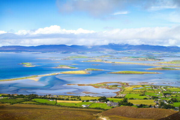
Ireland’s west coast and hidden heartlands are the perfect place to immerse yourself in nature and get under the skin of Irish life and culture. Running a mega 2,600km, Ireland’s Wild Atlantic Way is one of the longest-way marked coastal walks on earth. These coastal paths, forests, and mountains have been drawing visitors and pilgrims for centuries.
But the spectacular landscapes only tell show half the picture, and this nation of just over 5 million has punched above its weight on the world stage like no other. Delve into the country's rich cultural traditions and heritage to understand the full story of Ireland's past and its people. On this small island you'll find ancient standing stones, mysterious burial tombs and ruined castles alongside reinvented cities and one of the most dynamic economies in Europe.
More than anything, it’s the people of Ireland that leave a lasting impression on all those who visit. Whether regaling you with stories of old, feeding you plates of steaming stew or singing folk ballads in the local pub, the charm and spirit of the Irish people is something else. It’s something that neither the English language nor any film can truly convey. It’s a feeling, an experience that can only be understood when you stand on its shores and hear from its people.
So of course, you have to come to Ireland if you want a proper pint of Guinness, but don’t settle there, leave time to discover all the rest that this magical island has to offer.
Paths are usually marked but it’s always good to have map-reading and navigation skills, in case a sign is missed, has been damaged, or in case of disorientation in poor weather. The Ordnance Survey maps are the best ones to use.
You can book yourself, but the advantage of using a walking company is that they can advise on maps, route timings and the best places to stay along a route – and in Ireland you’ll welcome insights on things like where to eat or the best evening activities.
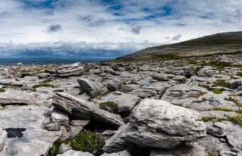
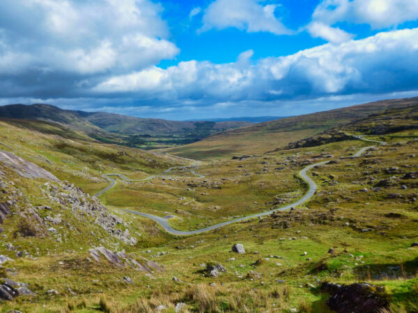
The Burren in County Clare is relatively flat and has some relaxing trails which take in some of the area’s unique limestone pavement, with lots of rare plants plus the chance to spot wildlife. The short looped trails in the Irish national parks are good first-time options too.
The Slieve Bloom Mountains in Co Laois and Offaly – there are 16 different looped walks and you can do the three-day 70 km Slieve Bloom Way, with quiet walking tracks and paths, and great views from the mountain tops. Alternatively the canal towpaths in the midlands are also a nice, flat option.
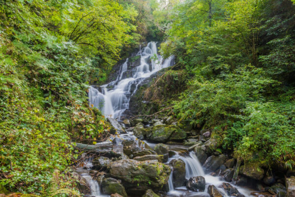
The town of Killarney, Co Kerry is a good base – you can explore Killarney National Park, around the three lakes, with a mix of short walks or mountain tracks to explore. You are based in a lively town for food, accommodation and traditional music sessions in the evening.
I love the southwest of Ireland, especially the peninsulas of Co Cork and Co Kerry, because you have the combination of amazing mountain and coastal scenery.
The Dingle Way is a great one – a 180 km route which loops around the Dingle peninsula, taking in mountains, cliffs, beaches and countryside paths, with some dramatic sea views. You can stop at villages and take in views of islands like the Blasket Islands.
You'll receive a reply by email. Questions and replies may be anonymised and reproduced on Horizon Guides.
§ 04
The Ireland atlas
10 picksPlaces & Experiences You Won't Find Elsewhere
Where
What
Difficulty: Easy to challengingDistance: 1,600 miles (2,600 km)Duration: Day hikes to multi-week treksStart Point: Kinsale, County CorkEnd Point: Malin Head, County Donegal
At 2,600 km in full, the Wild Atlantic Way is one of the longest way-marked coastal walks on earth. Unlike the rest of the walks on this page, the Wild Atlantic Way is rarely completed in one go, with most walkers hiking segments at a time.
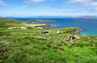
Traversing nearly half of Ireland’s Atlantic coast means you’ll find a wide range of landscapes from rocky shorelines and pebbled beaches to rolling hills and towering cliffs.
Good day hikes can be found along the full length of the Wild Atlantic Way. A popular route is the scenic walk along the Cleggan Cliffs towards the pebble-covered Ross Beach before heading to Kylemore Abbey to explore its landscaped gardens and then heading towards Renvyle Beach to watch the sunset.
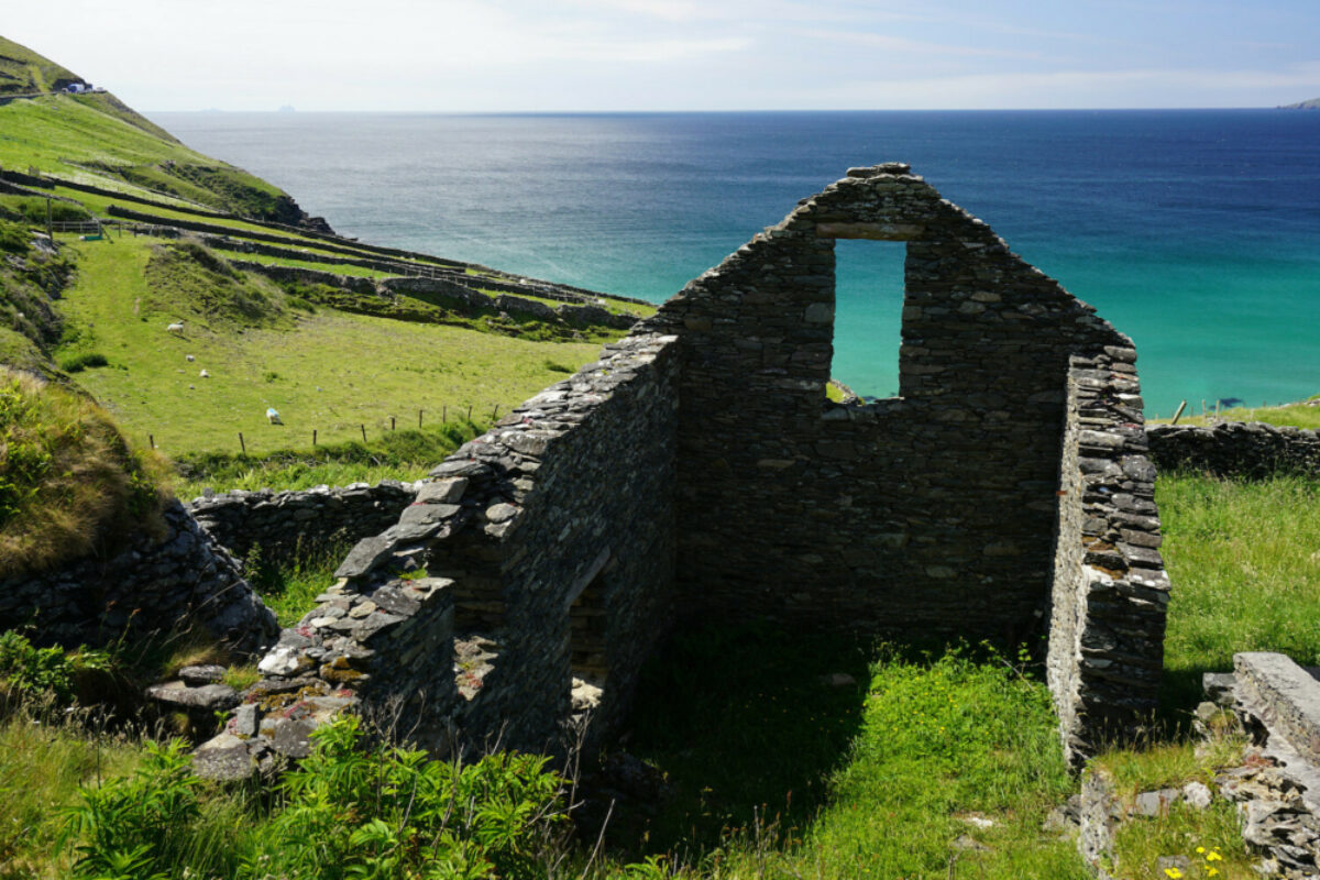
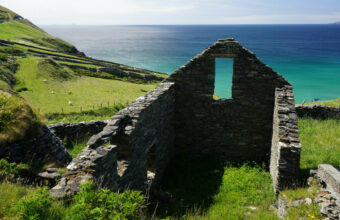
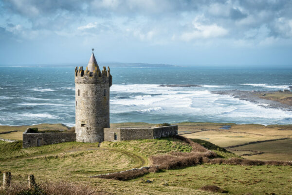
Other notable spots include Dún Briste, the 50m-high sea stack standing alone off the coast, Doonagore Castle near Doolin and the remains of Rosserk Friary in County Mayo.
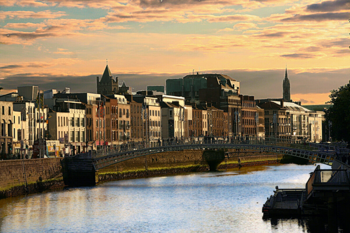
It also passes through popular destinations like Galway City as well as small harbour towns and villages including Skibbereen, Kenmare and Crookhaven that can provide accommodation and sustenance to hikers.
The difficulty of the Wild Atlantic Way varies greatly depending on the specific trail, with sections and segments suitable for most abilities.
Difficulty: ModerateDistance: approx. 155 miles (250 km)Duration: seven to ten daysStart Point: Oughterard, County GalwayEnd Point: Bunnyconnellan, County Mayo
The Western Way is a long-distance trail of 250 km which can be completed in its entirety over seven to ten days or walked in shorter segments. Exploring both County Mayo and County Galway in the west of Ireland, the trail starts in Oughterard and ends in Bunnyconnellan.
Highlights of the route include the stunning views from Croagh Patrick, Ireland's holiest mountain still climbed by around 20,000 pilgrims each year, Delphi Valley as well as loughs like Nafooey and Corrib. The route passes through traditional Irish villages like Leenane, brimming with pubs and cafes, as well as historical sites like Kylemore Abbey, a 19th-century castle surrounded by stunning gardens.
The Western Way is a moderate to challenging hike with steep ascents and descents as well as rocky and boggy terrain in parts. Passing through towns and villages regularly means accommodation is generally easy to organise although it is beneficial to book in advance during the busy season.
Difficulty: ModerateDistance: 58 miles (93 km)Duration: five to seven daysStart and End point: Bantry, County Cork
The Sheep's Head Way is a moderate difficulty circular route approximately 93 km long and typically takes about six days to complete. It starts and ends in the market town of Bantry, and heads right out to Sheep’s Head Lighthouse at the tip of the Muntervary Peninsula.
Traversing a range of landscapes from heather moors and quiet roads to forest paths, the route allows walkers to explore the peninsula. Dolphins and whales have been spotted in the area and with coastal views throughout—you could be in luck!
With St. Finbarr’s Pilgrim Path starting from the village of Drimoleague, the area is rich in history and heritage with several interesting sites along the trail. These include Ahakista Stone Circle and Gougane Barra; a small church perched beside a lake and an old copper mine.
The Sheep's Head Way is a relatively less-crowded route, ideal for those looking for a quieter hiking experience. The best time to hike is from April to October for milder weather.
Difficulty: StrenuousDistance: 43 miles (70 km)Duration: three daysStart point: Various
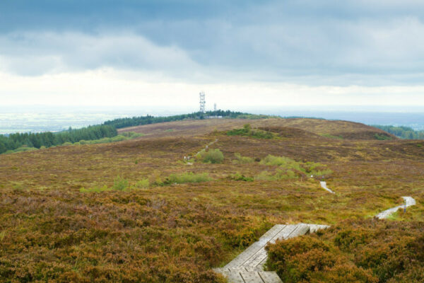
The Slieve Bloom Way is a 70 km circuit route that takes in the Slieve Bloom Mountains. It typically takes three days to complete, ascending about 1,275m. It can be started from a number of trailheads along the route although Glenbarrow Car park in County Laois has trail information and maps.
Along the way, you’ll cross the picturesque countryside of the Slieve Bloom Mountains, the Keeper Hills and the Esker Riada. Although the only accommodation on the trail is in Kinnitty, the route passes near several villages where accommodation can be organised in advance, often with optional transport to and from the trail. These include Clonaslee, Rosenallis and Cadamstown.
Following a mixture of forest, river, grass and sand paths, the route passes sites such as the Glenbarrow Waterfall, the remains of Glinsk Castle and the ruins of Baunreagh House as well as the Ridge of Capard to see the ancient Stoney Man cairn.
It's worth noting that the Slieve Bloom Way may not be as well-marked as other routes, so hikers should come prepared with a map and compass. It is considered challenging, with some steep inclines and uneven terrain. The best time to hike the Slieve Bloom Way is from April to October when the weather is milder and the flora is in bloom.
Difficulty: ModerateDistance: 70 miles (114 km)Duration: six to eight daysStart point: Lahinch, County ClareEnd point: Corofin, County Clare
The Burren Way is a 114 km long-distance walk that runs through the Burren, a unique limestone landscape in County Clare. The route starts in Lahinch, a popular surfing destination, but many walkers opt to begin in Liscannor. A moderate to challenging hike with steep climbs and rocky terrain, the trail skirts the coast to take in views of the Aran Islands and Galway Bay before ending at the village of Corofin on the Fergus River.
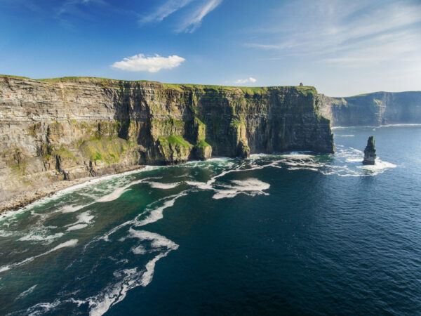
Along the way, you'll pass ancient sites like the Poulnabrone Dolmen, a megalithic tomb dating back to the Neolithic period, as well as the Caherconnell Stone Fort, an Iron Age ringfort. Notable spots include the Cliffs of Moher renowned for their immense coastal and island views, and the Aillwee Caves and Doolin Pier for views of the fossil-packed limestone.
The best time to hike the Burren Way is between April and October when the weather is mild and the wildflowers are in bloom. During peak season in the summer months it can be crowded.
Difficulty: Moderate Distance: 111 miles (179 km)Duration: seven to nine daysStart and end point: Tralee, County Kerry
The Dingle Way is a 179 km long-distance walking route completing a circuit of the Dingle Peninsula. Starting in Tralee, the route winds its way through the countryside, passing by ancient sites and traversing rugged cliffs to ascend 2,300 metres.
Highlights of the trail include the Gallarus Oratory, a well-preserved Christian church dating back to around the 11th century, and the ancient Leacanabuaile stone fort. As well as having panoramic views of the ocean and of the Blasket Islands, the trail also has views of the Conor Pass, one of the highest roads in Ireland. Along the way, hikers will also be able to enjoy the local culture and hospitality of the towns and villages they pass through, such as Camp, Lispole and Annascaul.
The Dingle Way is considered a moderate to challenging walk, with some steep inclines and rocky terrain in places best suited for experienced hikers.
Open all year round, the best time to complete the circuit is during the summer months when the weather is generally mild and dry with the peak season being June to September, so it's recommended to book accommodation in advance during these months.
Difficulty: Moderate to strenuousDistance: 128 miles (206 km)Duration: seven to nine daysStart and end point: Glengarriff, County Cork
The Beara Way is a 206 km circular route beginning and ending in Glengarriff, County Cork. Typically taking seven to nine days to complete, it is a moderate to challenging route, with some steep inclines and rocky terrain.
One of the highlights of the Beara Way is its beautiful coastal path, with breath-taking views of the ocean and the surrounding islands. Visit the charming villages of Castletownbere, Eyeries and Allihies to learn of its fascinating mining history at the local museum. Walkers will also enjoy panoramic views of the Caha Mountains from the famous Healy Pass.
The Beara Way passes the ancient Uragh Stone Circle, the mediaeval ruins of Dunboy Castle next to the abandoned shell of 19th century Puxley Mansion.
The route is widely offered as an organised (self-guided) tour by various walking holiday operators.
Difficulty: ModerateDistance: 133 miles (214 km)Duration: eight to twelve daysStart and end point: Killarney, County Kerry
The Kerry Way is a popular walking holiday route which starts and ends in Killarney and winds its way through rugged mountains, valleys and along the dramatic Atlantic coastline. The full route is 214 km and typically takes eight to twelve days to complete.
Along the way, hikers pass through various towns and villages such as Glenbeigh, Waterville and Sneem. Popular historical sites and landmarks include the Glenbeigh Castle, Muckross House and Gardens, the Staigue Fort as well as Derrynane House and Abbey.
The Kerry Way features views of the MacGillycuddy's Reeks, the Lakes of Killarney and the impressive Torc Waterfall as well as coastal views throughout. It is also great for birdwatching, with opportunities to spot a variety of species including puffins, from March to September.
A moderately difficult walking holiday, the trail has some steep climbs and rocky terrain in places, but is generally made up of well-marked paths. The route is busiest during the summer months, however, it is still relatively uncrowded even during peak season.
Difficulty: ModerateDistance: 79 miles (127 km)Duration: seven to nine daysStart Point: Marlay Park, Dublin CityEnd Point: Clonegal, County Carlow
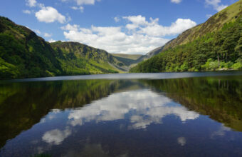
The Wicklow Way is a well-established route that runs through the Wicklow Mountains National Park. It covers about 79 miles (127 km) and typically takes seven to nine days to complete. The route traditionally begins in Marlay Park in Dublin City and ends in Clonegal, County Carlow, but it can be walked in the opposite direction for a gentler start.
The Wicklow Way is renowned for the dramatic scenery of its glacial valleys, deep lakes and native woodlands. Winding through heather-covered mountains and rolling hills with occasional stretches of road walking, the Wicklow Way passes through the picturesque villages of Roundwood, Laragh and Hollywood.
A haven for native flora and fauna, and rich in history and heritage, interesting sites to explore along the route include ancient standing stones, ruined castles and old mines. Historic houses include; the Powerscourt Estate, an impressive country house with landscaped gardens and a cascading waterfall; Newtownbarry house with its gardens and gallery and Russborough House, an 18th-century stately home with a birds of prey centre. Visitors can explore Glendalough Valley, home to one of Ireland’s best-preserved monastic sites which dates all the way back to the 6th century.
The Wicklow Way is a moderate difficulty walking holiday, with steep climbs up glacial valleys as well as forest and farmland walks. It is well-signposted, with well-trodden paths and occasional road walking. It can be busy during peak season, which is typically during the summer months, from June to September.
The walk is widely offered as a self-guided tour by walking holiday companies who will organise your transfers, accommodations and daily baggage transfers.
Distance: Approximately 71 miles (114 km)Duration: Four to six daysStart and end point: Lowtown to St. MullinsDifficulty: Easy to moderate
The Barrow Way is a delightful 71-mile trail that can be completed in four to six days, depending on your pace. It runs from Lowtown in County Kildare to St. Mullins in County Carlow. This long-distance walking and cycling route follows the picturesque path of the River Barrow.
With its gentle terrain and well-marked signposts, the Barrow Way is suitable for both beginners and experienced hikers. Along the way, you'll be enchanted by the serene countryside, charming villages, and lush woodlands that line the riverbanks.
Keep an eye out for ancient monastic sites, like the ruins of Graiguenamanagh Abbey, and the historic Leighlinbridge.
Planning for the Barrow Way is relatively straightforward. There are accommodations available in the towns and villages along the route, ranging from guesthouses to bed and breakfasts.
Your details are safe and will not be used for any other purpose. By using this service you agree for us to share your details with your chosen tour operator according to our Privacy Policy.