


The Best California Road Trip Routes
Off the beaten path in The Golden State
Top California road trips:
Top California road trip itineraries
California beach town route
While there are many attractions to enjoy in sprawling Los Angeles and the buzzy Bay Area, a road trip through California’s smaller coastal communities allows visitors to slow down and get a glimpse of local life. Whether it’s a Southern California surf town like Encinitas or a rugged Northern California outpost like Point Arena, the communities featured here all have unique identities, stunning natural areas, and access to fresh seafood hauled in from the nearby Pacific Ocean.
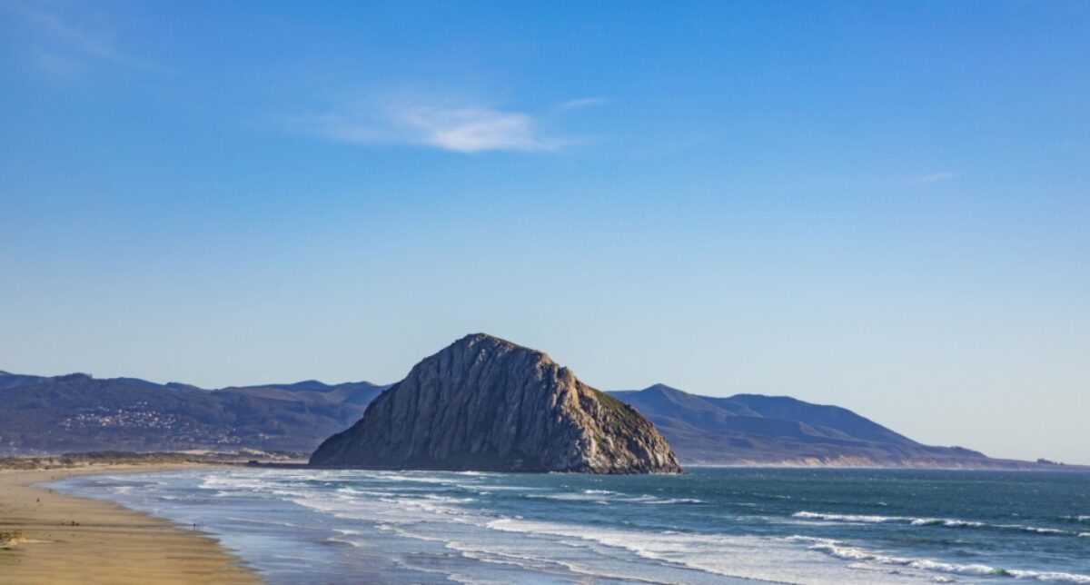
'Gibraltar of the Pacific' in Morro Bay, California
California beach town route
Approx. distance: 600 miles
Duration: Six to 10 days
Suggested route: San Diego, Encinitas, Carpinteria, Morro Bay, Pacific Grove, Point Arena, Trinidad.
The route
The beach town of Encinitas is located a half hour drive north of San Diego. It is possible to take a drive from Encinitas to Carpinteria in three hours—if you don’t get ensnared in Los Angeles traffic. It’s best to avoid driving through Los Angeles between 7am and 10am and also between 4pm and 7pm. It is advised to look at the online Los Angeles Traffic Report (www.sigalert.com) before heading out.
It’s another two-hour drive north from Carpinteria to Morro Bay on Highway 101. One recommended stop is almost exactly halfway at the seven-block town of Los Alamos, located right off the highway. Los Alamos looks like an old Western movie set and has fine restaurants and wine tasting rooms.
There are two main ways to get from Morro Bay to Pacific Grove on the Monterey Peninsula. The highly recommended, longer route is on the twisting and turning Highway 1 through Big Sur, which takes at least three hours or more. The shorter but much less dramatic option if you get carsick is the two and a half hour drive up the inland Highway 101.
The route from Pacific Grove to Half Moon Bay is a scenic, two hour drive up Highway 1. Be aware that the highway passes through Santa Cruz, which can have some highway backup particularly in the afternoon.
The drive from Half Moon Bay up to Point Arena is more substantial. The route includes getting on Highway 101 and passing through San Francisco and over the Golden Gate Bridge before heading west to the coast at Bodega Bay by utilising Roblar Road and Valley Ford Road. Once in Bodega Bay, just head north on windy, scenic Highway 1 for two hours until Point Arena.
To reach Trinidad from Point Arena, take Highway 1 north until it heads inland and intersects with Highway 101 in Leggett. Then take Highway 101 North to Trinidad. Note that above Leggett, motorists can opt to take Avenue of the Giants, a stunning roadway through the redwoods that parallels Highway 101 for 31 miles.
Big Sur
If you're driving the California coast there's no avoiding Big Sur, an incredible 90 mile stretch of coastal mountains, iconic cliff-side bridges, waterfalls, and redwoods towering above the Pacific surf. There are two waterfalls right off Highway 1 that are worthy of stops. The first is Salmon Creek Falls, 50 miles north of Morro Bay and a 10 minute walk east from the highway for the best view. The other is McWay Falls at Julia Pfeiffer Burns State Park, which is 80 miles north of Morro Bay. McWay Falls is an 80 foot waterfall that lands right on a beach by the ocean. All this beauty comes at a cost; Big Sur gets very busy on summer and holiday weekends. Best to time your drive for other days, the golden hour before sunset is particularly dramatic.
Highlights
Encinitas
If you ever wanted to learn how to surf, Encinitas might be the place to paddle out for the first time. The water here is warmer than the northern section of the California coast, and there’s many world-renowned surf breaks including Swami’s, which was sung about in the Beach Boys’ “Surfin’ USA.”
In addition to being a classic SoCal surf town, Encinitas is also known for its flowers due in large part to the San Diego Botanic Garden being located there.
Carpinteria
Just 15 minutes from Santa Barbara, Carpinteria is a pleasant coastal community known for its gentle beaches, walkable downtown, and annual avocado festival, which takes place the first weekend in October. It’s also near Rincon, one of the world’s most renowned surf breaks.
Morro Bay
Towering over the town of Morro Bay and its harbour is the 576-foot-tall Morro Rock that is known as the “Gibraltar of the Pacific.” It’s worth standing on the adjacent beach and taking in the unique geologic phenomenon.
Morro Bay is also a great place to dine on locally caught seafood or take a hike in one of the nearby state parks (Morro Bay State Park, Moñtana de Oro State Park).
Pacific Grove
Sandwiched between the Monterey Peninsula towns of Carmel and Monterey, Pacific Grove is a former Methodist summer retreat now known for its scenic coastline and Victorian architecture. You’ll find it much quieter than the more famous (and rather touristy) Carmel and Monterey, making it a fine base to explore the Monterey Peninsula. It gained more exposure recently for being one of the major filming locations of the hit HBO series Big Little Lies.
Point Arena
There’s much to recommend about this tiny coastal city in Mendocino County including its natural harbour, historic lighthouse, and the amazing seaside hiking trails of the California Coastal National Monument’s Point Arena-Stornetta Unit. If it’s a low tide, make your way to Bowling Ball Beach south of town where lines of boulders make for a superb photo-op.
Trinidad
This seaside town in Humboldt County is one of the state’s smallest and most scenic. While here, hike out on Trinidad Head, a rocky promontory with views of the adjacent bay. Or walk below the coastal bluffs on Trinidad State Beach. Also recommended is a trip to Patrick’s Point State Park, a stunning little state park located just six miles north of Trinidad.
California gold rush road trip
The discovery of gold in California in 1848 and the following gold rush of 1849 drew prospectors from around the world to the rolling foothills of the Sierra Nevada Mountains. Highway 49 is a north-south roadway that connects the small historic cities and notable sites of the gold rush era, while also offering access to some of the state’s underrated parks, rivers, and natural areas. An added bonus are the acclaimed wineries and tasting rooms that have begun to proliferate in the region.
California gold rush road trip
Approx. distance: 300 miles
Duration: Three to five days
Suggested route: Mariposa, Sonora/Jamestown/Columbia, Sutter Creek/Volcano/Amador City, Placerville, Grass Valley/Nevada City.
The route
Take your time driving on the winding but scenic Highway 49. Start in the south at the town of Oakdale and head north. It’s recommended to spend two to three nights in some of the small historic towns along the way. Some possible worthwhile overnight options include Sonora in the south, Jackson/Sutter Creek in the middle, and Grass Valley/Nevada City on the north end.
Highway 49 is a well-maintained road. That said, it is possible you’ll get stuck behind a lumber truck or RV that would slow your progress.
Be aware that winter and spring usually brings rain to the region but snow is less common at that elevation. In addition, there is the possibility of wildfires in the summer and fall months.
Highlights
Mariposa
Scenic Mariposa is the southernmost of the gold rush towns. It is home to the oldest continuously operating courthouse west of the Rockies and the Mariposa Museum and History Center, which has artefacts from the mining days along with recreations of old dwellings and stores. At the Mariposa Fairground is the California State Mining & Mineral Museum and its collection of 13,000 gems including an almost 14-pound chunk of crystalline gold.
Yosemite National Park is just an hour drive from Mariposa and definitely worth the detour if you have some spare time.
Sonora/Jamestown/Columbia
This trio of California gold rush towns are located just a few miles apart. Named for the Mexican miners that founded it, Sonora is the largest of the three and where the Tuolumne County Museum and History Center is located.
A visit to nearby Jamestown allows visitors to experience a ride on a historic steam or diesel locomotive at Railtown 1897 State Historic Park. Possibly, the most popular for history buffs is Columbia due to the presence of Columbia State Historic Park, a preserved gold rush town with park workers in period attire and almost 30 buildings.
Sutter Creek/Volcano/Amador City
Just outside of Jackson, the county seat of Amador County, are a trio of gold rush era towns, each with their own reasons to visit. (Both Sutter Creek and Amador City are on Highway 49, while Volcano is a half hour off the historic roadway.)
Sutter Creek has a charming downtown with 19th Century buildings and is home to the Knight Foundry, a water powered foundry and machine shop established in 1873 that is open for tours. Nearby Amador City is one of the state’s smallest incorporated cities and has exhibits focusing on women from the gold rush era and beyond at the Amador Whitney Museum.
At one time, the town of Volcano had 17 hotels, but now has two historic places to lay your head: The Volcano Union Inn & Pub and the St. George Hotel. Volcano is also home to Daffodil Hill, a meadow that explodes with yellow and white daffodils in the springtime.
Placerville and the Marshall Gold Discovery State Historic Park
Once the third largest town in California, Placerville was also known as “Hangtown” due to the numerous hangings that occurred there. A mile north of Placerville’s Main Street is Gold Bug Park, where visitors can take a tour of a former gold mine. Even more worthwhile is the 20-minute drive north on Highway 49 to the Marshall Gold Discovery State Historic Park, the site where the gold rush began after James W. Marshall found gold at Sutter’s Mill in 1848.
Grass Valley and Nevada City
The two charming gold rush towns of Nevada City and Grass Valley are four miles apart. Nevada City is known for its Victorian buildings, while Grass Valley is the commercial centre in the region and home to the Holbrooke Hotel dating back to 1862. Also, in Grass Valley is Empire Mine State Historic Park, where 5.8 million ounces of gold were extracted over the years.
Twenty-six miles from Nevada City, Malakoff Diggins State Historic Park still shows the environmental degradation of gold mining on the landscape. Here at California’s largest hydraulic, gold mine miners washed away sections of entire mountains in their attempts to find gold.
Northern California road trip
North of San Francisco, California becomes less populated and wilder. Here nature dominates the landscape from the skyscraping redwood trees to the crashing waves on the rugged coast to the volcanic wonders bubbling inland. Northern California is also the place to see magnificent wild animals whether it’s the migrating gray whales off Bodega Bay or the majestic Roosevelt elk wandering around Prairie Creek Redwoods State Park.
Northern California road trip
Approx. distance: 600 miles
Duration: Seven to 10 days
Suggested route: Bodega Bay, Avenue of the Giants, Redwood National & State Parks, Mount Shasta, Lassen Volcanic National Park.
The route
This road trip begins in Bodega Bay, but there’s a good chance you’d leave from San Francisco, which is located an hour and a half south of Bodega Bay. The small town of Bodega Bay is located on the scenic but winding Highway 1. To reach Avenue of the Giants on the quickest route from Bodega Bay, which takes three and a half hours, take the Bodega Highway and CA-12 to reach U.S. 101 North in Santa Rosa. A scenic but slower option is to take the coastal route along Highway 1 to Avenue of the Giants, which takes five hours.
The drive from Avenue of the Giants to the Redwood National and State Parks is an easy two-hour journey up Highway 101. The greatest challenge is deciding whether to stop in the college town of Arcata, the scenic community of Trinidad, or the stunning coastal Patrick’s Point State Park along the way. Maybe stop at each one?
The trip from the Redwood National and State Parks inland to Mount Shasta is long and a bit gruelling due to there being no great route from west to east. You actually have to head up and over into Oregon before dropping into central California. The recommended way between the two points is to take U.S. 101 North and then head northeast on U.S. 199 before taking U.S. 5 South. The one benefit is that there are a few worthwhile stops on the route including Oregon Caves National Monument in Cave Junction, Oregon and Ashland, Oregon, a scenic town that is home to an annual Shakespeare festival.
The last stint of the journey is a relatively easy two-hour drive from Mount Shasta to Lassen Volcanic National Park.
Highlights
Bodega Bay
A small, coastal community, Bodega Bay is the place to go if you want to spot some wildlife. Known for being the setting of Alfred Hitchcock’s The Birds, Bodega Bay is where to view migrating gray whales either by hiking out onto Bodega Head or hopping on one of the local fishing boats that offers whale watching cruises.
Bodega Bay is also a great place to get a meal of fresh seafood whether it’s a crab sandwich from the Spud Point Crab Company or a fish taco from the Fishetarian Fish Market.
Avenue of the Giants
The Avenue of the Giants is a scenic 31-mile long road through stunning groves of redwood trees along the twisting Eel River. There are over 50,000 acres of redwood forest here including many preserved specimens within Humboldt Redwoods State Park and Richardson Grove State Park. For a unique experience, make sure to head over to the Shrine Drive Thru-Tree in Myers Flat, at the southern end of Avenue of the Giants, to drive your vehicle through a redwood tree.
Redwood National and State Parks
Redwood National and State Parks is actually comprised of several parks including Prairie Creek Redwoods State Park, Del Norte Coast Redwoods State Park, and Jedidiah Smith Redwoods State Park. While all showcase the rugged beauty of Northern California, Prairie Creek Redwoods is the best for its variety. At the park, you can take in redwoods along the Cathedral Trees Trail, watch Roosevelt elk in Elk Prairie, and walk in a fern-draped canyon on the Fern Canyon Trail.
Mount Shasta
Mount Shasta is actually several things: a 14,179-foot-high potentially active volcano that looms over the landscape, a ski resort located on the peak, a city that also goes by the name of Mount Shasta City, and the region in general. To summit the peak involves a tough climb with ice axes and crampons. Another option is to ski down a part of it within Mt Shasta Ski Park. Or you can just take in the majestic peak from downtown Mount Shasta City or Castle Crags State Park.
Lassen Volcanic National Park
A wonderland of geothermal activity and volcanic geology, Lassen Volcanic National Park is one of the oldest national parks in the United States. While here, attempt to summit the 10,457-foot-high Lassen Peak, take in the results of geothermal activity at Bumpass Hell, or head outside of the park into Lassen National Forest to hike through the 1/3-mile-long lava tube known as Subway Cave.
About the author
Stuart Thornton
Stuart is a California-based travel writer and guidebook author. His books include Moon California Road Trip, Moon Coastal California and the forthcoming Moon Northern California Road Trips. For more about Stuart and his books, visit his website.

Find a The Best California Road Trip Routes specialist
Tell us about your trip and we'll find your match
We'll connect you directly with the experts.


We'll connect you directly with the experts.
- Hand-picked local specialists
- Honest advice from real experts
- Free to use, no hidden fees