


The best Coast to Coast Path route
The best Coast to Coast Path itinerary
-
St Bees Head
... -
Borrowdale
... -
Grasmere
... -
Ullswater
... -
Shap
... -
Kirkby Stephen
... -
Keld
... -
Reeth
... -
Richmond
... -
Danby Wiske
... -
Ingleby Cross
... -
Blakey Ridge
... -
Grosmont
... -
Robin Hood’s Bay
...
Considered by some to be the best long-distance walk in the UK, Wainwright’s Coast to Coast Path has many remarkable qualities, but it’s the walker camaraderie that is my stand-out highlight of this hugely popular cross-country hike.
The scenery is at times stunning – looking at you, Lake District – but the sense of community you experience with fellow walkers is felt here on this walk perhaps more than on any other in Britain.
This is largely due to the fact that many, if not most walkers tackle the Coast to Coast Path in one go (or at least in two halves), rather than dipping in and out of it on day- or weekend-hikes as many people do for Britain’s other long-distance trails. The result is that you’ll bump into the same people again and again over the course of your two-week walk, in pubs, cafes and hostels along the route, where you can share a drink, and compare blisters whilst drying your bog-drenched toes in front of a roaring log fire.
The Coast to Coast isn’t an official National Trail. Instead, it was the brainchild of the legendary fell walker and guidebook writer Alfred Wainwright, who in 1973 decided to plot a walk-to-remember across the width of the country which, as far as he knew, wouldn’t break any trespassing laws. Two-thirds of the trail is spent walking through three of England’s 10 national parks (The Lake District, The Yorkshire Dales and the North York Moors) and the route includes some of the most dramatic upland scenery in England. Prepare to be blown away by the beauty of some of the Lake District sections. Prepare also for quite a lot of rain.
My recommended itinerary breaks the route down into the following segments, walking from west to east. You can do it all in one straight shot, but lots of people break it up into weekend hikes.
Good to know
- Distance: 190.5 miles (306.5km)
- Duration: 14 days
- Start point: St Bees
- End point: Robin Hood’s Bay
- Difficulty: Moderate to hard – very hilly through the Lake District stages; poorly waymarked in places, particularly over the Pennines; expect rain and boggy ground at times
- Suitable for: Fit walkers with a sense of adventure
Key information
| Destinations | The United Kingdom |
|---|---|
| Activity | Adventure, Trekking, Active, Walking, Camping, Nature & Wildlife, Photography, Birdwatching, National Parks |
| Physical Level | Moderate |
| January - December |
Featured tours
Featured tours

The best Coast to Coast Path route itinerary

St Bees – Ennerdale
Day 1 in St Bees Head
Begin at the Irish Sea with the customary dipping of boots before ascending St Bees Head, passing coastal cliffs. From here, the route turns inland, crossing gentle farmland and quiet villages to finish beside Ennerdale Water, at the entrance to the Lake District.
- 14 miles

Ennerdale – Borrowdale
Day 2 in Borrowdale
This section journeys deeper into the Lake District, following the tranquil shores of Ennerdale Water before rising into remote valleys and mountain scenery. The path concludes with a descent into Borrowdale, a classic Lakeland valley surrounded by steep slopes.
- 15 miles

Borrowdale – Grasmere
Day 3 in Grasmere
The walk ascends steeply out of Borrowdale over Greenup Edge, offering views of surrounding fells and quiet upland tarns. After crossing open moorland, it gently descends into Grasmere, a small village associated with William Wordsworth.
- 9 miles

Grasmere – Patterdale
Day 4 in Ullswater
Leaving Grasmere, the route climbs over Grisedale Pass, passing Grisedale Tarn nestled beneath high crags. The path then gradually descends through open valley scenery into Patterdale, beside Ullswater lake.
- 8.5 miles

Patterdale – Shap
Day 5 in Shap
The trail climbs sharply onto high ground around Kidsty Pike, the highest point on the Coast to Coast, with sweeping panoramas of surrounding hills and Haweswater below. It then gradually descends through rural landscapes, emerging from the Lake District into the village of Shap.
- 15.5 miles

Shap – Kirkby Stephen
Day 6 in Kirkby Stephen
This lengthy stage crosses limestone pavement, moorland, and farmland, marking a transition from Cumbria into Yorkshire. The route is punctuated by archaeological sites and ends at Kirkby Stephen, a market town with historic significance.
- 20.5 miles

Kirkby Stephen – Keld
Day 7 in Keld
Today involves crossing the Pennines via the dramatic landscape around Nine Standards Rigg, an upland area marked by stone cairns. The path then descends towards the small, secluded village of Keld in Swaledale, marking the halfway point.
- 13 miles

Keld – Reeth
Day 8 in Reeth
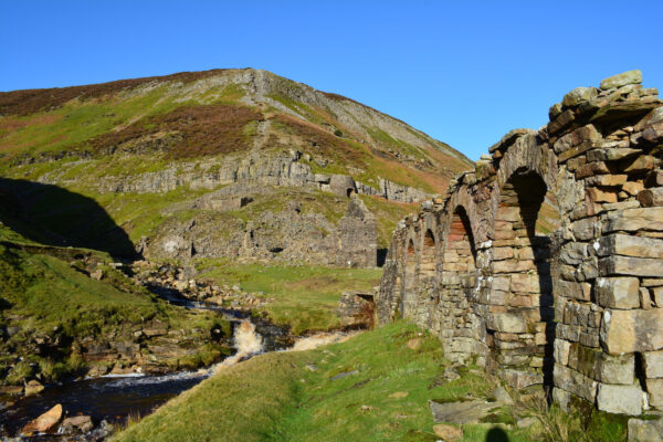
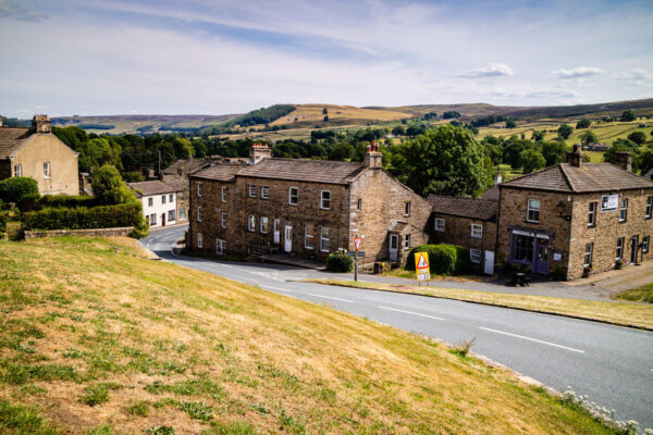
This stretch passes through picturesque Swaledale, with its characteristic stone barns and lush meadows enclosed by drystone walls. Historical remnants of lead mining are evident along the route, which ends in the village of Reeth.
- 11.5 miles

Reeth – Richmond
Day 9 in Richmond
Following the river Swale, the path gently winds through woodland and open countryside, providing pleasant walking and varied rural views. Richmond, a substantial town with a castle and Georgian architecture, marks the day’s end.
- 10.5 miles

Richmond – Danby Wiske
Day 10 in Danby Wiske
Departing Richmond, the route is predominantly flat, traversing quiet agricultural landscapes, with fields and occasional villages. The day's journey concludes at Danby Wiske, a village known for its peaceful simplicity.
- 13 miles

Danby Wiske – Ingleby Cross
Day 11 in Ingleby Cross
This stage is mostly level terrain, crossing farmland and country lanes, with distant views of the Cleveland Hills emerging later in the day. The route ends at the village of Ingleby Cross, at the edge of the North York Moors.
- 10 miles

Ingleby Cross – Blakey Ridge
Day 12 in Blakey Ridge
A challenging day characterised by ascents onto open moorland, the route navigates through heather-covered hills and the expansive scenery of the North York Moors. It finishes high at Blakey Ridge, offering far-reaching views in every direction.
- 21 miles

Blakey Ridge – Grosmont
Day 13 in Grosmont
Descending gradually, the path winds through valleys and moorland, passing through small hamlets and woodland. Grosmont, known for its heritage steam railway, provides an atmospheric overnight stop.
- 13.5 miles

Grosmont – Robin Hood’s Bay
Day 14 in Robin Hood’s Bay
The final leg starts with a climb out of Grosmont, crossing moorland and farmland, before reaching the North Sea cliffs. The route concludes by descending into Robin Hood’s Bay, where tradition dictates boots are dipped once more, this time in the sea.
- 15.5 miles
The Coast to Coast Path: Need to know
Where to stay
Budget walkers rejoice – the Coast to Coast path has an abundance of youth hostels, meaning you can stay in cheap dormitory-style accommodation without breaking the bank.
There’s also plenty of opportunity to camp, particularly in the Lake District where so-called ‘wild camping’ may be tolerated in places. That great British institute, the B&B, is also well represented all along the route.
My Coast to Coast highlights
Starting from the beach at St Bees, beside the Irish Sea, the first five days of the Coast to Coast Path are an undoubted highlight as you climb your way through the spectacular hills, lakes and valleys of the Lake District – so special it was awarded Unesco World Heritage status in 2017.
Over the first couple of days, you’ll walk the craggy shoreline of Ennerdale Water, trot past YHA Black Sail, the most remote hostel in England, and climb up and over the rocky pass near Honister Slate Mine, before descending into the lush valley of Borrowdale, with its trio of stone-cottage hamlets.
The climb up and over Greenup Edge is challenging for sure, but the views are breathtaking, and it’s now just a short stroll into the pretty village of Grasmere, home to a plethora of teahouses, cafes, and B&Bs, a 150-year-old gingerbread shop, and Dove Cottage, where former poet laureate William Wordsworth once lived. The climb up the Great Tongue to the tiny mountain lake of Grisedale Tarn leaves me gasping, but it’s a pleasant walk down Grisedale Valley, under the shadow of 950m-tall Helvellyn, to the cute village of Patterdale, with its sheep-filled fields and walker-friendly White Lion pub.
Climbing out of Patterdale is a joy, up and over Angletarn Pike, where you sometimes see wild deer, and the even higher Kidsty Pike before descending to the huge Haweswater Reservoir en route to Shap.
Sadly, the Lakes are behind you now, but that means the walking gradients become easier so you can begin to cover more miles each day. Historic Kirkby Stephen is your next stop before you climb up and over the Pennines on a day often clouded in mist, or obscured by rain – I find the waymarking hard to follow here – before you crawl, often exhausted, into lovely Keld, with its collection of ‘forces’ (waterfalls), for a well-earned rest. Pastoral Swaledale Valley leads you to Reeth with its welcoming pubs and numerous places to stay, then it’s on through farmland to centuries-old Richmond, the largest settlement on the path, and home to the formidable Richmond Castle.
The next couple of days are forgivingly flat before you hit the heather-covered North York Moors and climb up to remote Blakey Ridge, where a bed, a meal and a pint await at the 500-year-old Lion Inn, the walk’s most iconic pub.
You’re now just a hop, skip and a jump from the North Sea, via the lost-in-time village of Grosmont (steam trains, anyone?), the fairytale-like woods of Little Beck and the squelchy bogs of Sneaton Low Moor. Sweeping views abound as you follow the east coast of England south to Robin Hood’s Bay where a celebratory pint at Bay Hotel’s Wainwright’s Bar is the order of the day.

